IMAGES TAKEN NEAR TO
Park Avenue, CHIPPENHAM, SN14 0HA
Introduction
This page details the photographs taken nearby to Park Avenue, SN14 0HA by members of the Geograph project.
The Geograph project started in 2005 with the aim of publishing, organising and preserving representative images for every square kilometre of Great Britain, Ireland and the Isle of Man.

There are currently over 7.5m images from over14,400 individuals and you can help contribute to the project by visiting https://www.geograph.org.uk
Image Map (Loading...)


Getting Data...Please wait
Leaflet Map data © OpenStreetMap
Images are licensed for reuse under creativecommons.org/licenses/by-sa/2.0
Notes
- Clicking on the map will re-center to the selected point.
- The higher the marker number, the further away the image location is from the centre of the postcode.
Image Listing (20 Images Found)
Images are licensed for reuse under creativecommons.org/licenses/by-sa/2.0
Image
Details
Distance
2
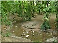
The Hardenhuish Brook
Probably never much of a watercourse at the best of times, but with only a trickle of a flow in the dry summer of 2022.
Image: © Stephen Craven
Taken: 13 Jul 2022
0.09 miles
3
Chippenham Astro-Turf Project - Hockey Pitch
Image: © Betty Longbottom
Taken: 29 Aug 2008
0.14 miles
4
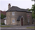
Old Toll House by Bristol Road, Chippenham
Folly Toll House by the A420, in parish of Chippenham Without (North Wiltshire District), Turnpike Cottage, Bristol Road, SN14 6HH.
Grade II listed.
List Entry Number: 1022906 https://historicengland.org.uk/listing/the-list/list-entry/1022906
Surveyed
Milestone Society National ID: WI.CHI02
Image: © Alan Rosevear
Taken: 18 May 2005
0.16 miles
5
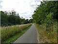
Cycleway parallel to the Hardenhuish Brook
This foot and cycle path runs for 1.1km alongside the Hardenhuish Brook from Bristol Road on the outskirts of the town centre to Stainers Way, beyond which it continues as a public footpath only, to and beyond the ring road.
Image: © Stephen Craven
Taken: 13 Jul 2022
0.16 miles
6
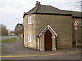
'Turnpike Cottage'
A former tollhouse on the A420 Bristol Road junction with the B4528 Hardenhuish Lane, an area once known as Folly Gate. It may have been built in around 1830 for the Chippenham Turnpike Trust. See Image] for a peculiar benchmark.
Image: © Neil Owen
Taken: 29 Feb 2012
0.17 miles
7
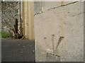
Inverted benchmark
It's not terribly common but sometimes the arrows are above the datum line. However, it may be that the mark was originally positioned elsewhere at Folly Gate and the stonework reused after rebuilding. Historic references appear to indicate the mark at this location since the late 1880s. See http://www.bench-marks.org.uk/bm41652 for the Benchmark Database, or Image] for a look at the old turnpike tollhouse.
Image: © Neil Owen
Taken: 29 Feb 2012
0.17 miles
8
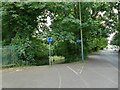
Cycleway off Hardenhuish Lane
Part of a longer foot and cycle path that runs for 1.3km alongside the Hardenhuish Brook from the ring road to Bristol Road on the outskirts of the town centre.
Image: © Stephen Craven
Taken: 13 Jul 2022
0.17 miles
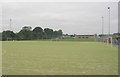
10
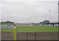
Chippenham Town Football Club - Bristol Road
Image: © Betty Longbottom
Taken: 29 Aug 2008
0.18 miles