IMAGES TAKEN NEAR TO
Curlcroft Road, CORSHAM, SN13 9RR
Introduction
This page details the photographs taken nearby to Curlcroft Road, SN13 9RR by members of the Geograph project.
The Geograph project started in 2005 with the aim of publishing, organising and preserving representative images for every square kilometre of Great Britain, Ireland and the Isle of Man.

There are currently over 7.5m images from over14,400 individuals and you can help contribute to the project by visiting https://www.geograph.org.uk
Image Map
Images are licensed for reuse under creativecommons.org/licenses/by-sa/2.0
Notes
- Clicking on the map will re-center to the selected point.
- The higher the marker number, the further away the image location is from the centre of the postcode.
Image Listing (6 Images Found)
Images are licensed for reuse under creativecommons.org/licenses/by-sa/2.0
Image
Details
Distance
1
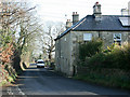
2008 : Greenhill
The area between Corsham and Rudloe is full of tiny villages, hamlets and industrial estates which together would make a small town.
This is at Greenhill.
Image: © Maurice Pullin
Taken: 25 Feb 2008
0.16 miles
2
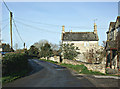
2008 : Greenhill south west of Corsham
Another example of the group of hamlets gathered to the south and west of Corsham.
An interesting area, it contains the eastern end of the Box Tunnel, industrial estates, stone mines and an R.A.F. Station.
Image: © Maurice Pullin
Taken: 25 Feb 2008
0.17 miles
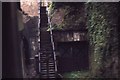
3
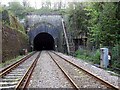
Box Tunnel
This photo shows the eastern portal of Box Tunnel. If you look closely you will see the size of the original entrance, also there is a further reduction in size about 100 feet into the tunnel, this was done so as not to scare people in the 1840's. The secondary entrance on the right takes a railway line into Tunnel Quarry that was started about the same time as Box Tunnel (1836).
Tunnel Quarry was taken over by the War Department during the 1930's and was converted into one of the largest underground ammunition depots in the world (approx 1,250,000 sq ft. of storage space), these tracks run for over a 1/4 of a mile and end in an underground station with 2 platforms each 200 metres long.
Image: © Derek Hawkins
Taken: 23 Apr 2005
0.17 miles
4
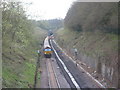
Box Tunnel East
Track Re-laying in the cutting viewed from Potley Bridge.
Image: © Ben Croft
Taken: 9 Apr 2005
0.18 miles
5
Heading east out of Box Tunnel
The secondary entrance on the right takes a railway line into Tunnel Quarry - see Image for more information
Image: © Elliott Simpson
Taken: Unknown
0.20 miles
6
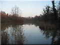
Pockeridge Lake In Wintertime
All quiet - before Katherine Park!
Image: © Ben Croft
Taken: 11 Dec 2004
0.22 miles