IMAGES TAKEN NEAR TO
Ladbrook Lane, CORSHAM, SN13 9PF
Introduction
This page details the photographs taken nearby to Ladbrook Lane, SN13 9PF by members of the Geograph project.
The Geograph project started in 2005 with the aim of publishing, organising and preserving representative images for every square kilometre of Great Britain, Ireland and the Isle of Man.

There are currently over 7.5m images from over14,400 individuals and you can help contribute to the project by visiting https://www.geograph.org.uk
Image Map
Images are licensed for reuse under creativecommons.org/licenses/by-sa/2.0
Notes
- Clicking on the map will re-center to the selected point.
- The higher the marker number, the further away the image location is from the centre of the postcode.
Image Listing (5 Images Found)
Images are licensed for reuse under creativecommons.org/licenses/by-sa/2.0
Image
Details
Distance
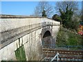
2
2008 : West from Ladbrook Lane Bridge near Corsham
A gentleman passing told me the next bridge, in sight here, is the highest in elevation on the Bristol to Paddington line.
Image: © Maurice Pullin
Taken: 17 Feb 2008
0.11 miles
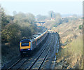
4
2008 : From Ladbrook Lane Bridge
An HST for First Great Western has just passed under Ladbrook Lane bridge on its way to Paddington.
Image: © Maurice Pullin
Taken: 17 Feb 2008
0.16 miles
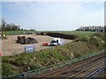
5
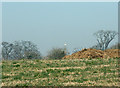
2008 : Flying object identified
The "UFO" about to fly over the manure heap is the weathercock on the spire of Corsham Church.
Image: © Maurice Pullin
Taken: 17 Feb 2008
0.16 miles