IMAGES TAKEN NEAR TO
Alcombe, CORSHAM, SN13 8QH
Introduction
This page details the photographs taken nearby to Alcombe, SN13 8QH by members of the Geograph project.
The Geograph project started in 2005 with the aim of publishing, organising and preserving representative images for every square kilometre of Great Britain, Ireland and the Isle of Man.

There are currently over 7.5m images from over14,400 individuals and you can help contribute to the project by visiting https://www.geograph.org.uk
Image Map
Images are licensed for reuse under creativecommons.org/licenses/by-sa/2.0
Notes
- Clicking on the map will re-center to the selected point.
- The higher the marker number, the further away the image location is from the centre of the postcode.
Image Listing (6 Images Found)
Images are licensed for reuse under creativecommons.org/licenses/by-sa/2.0
Image
Details
Distance
1
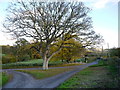
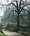
Oak tree at Alcombe
The tree occupies a classic grass triangle at a three-way lane junction.
Image: © Jonathan Billinger
Taken: 19 Nov 2013
0.03 miles
2
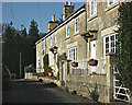
2008 : Cottages at Alcombe
The conifers in the background give a dramatic effect to these cottages in the morning sun.
Image: © Maurice Pullin
Taken: 12 Feb 2008
0.06 miles
3
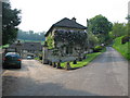
Alcombe Manor
A view looking to the northwest along the lane leading up to Banner Down, showing Alcombe Manor on the left.
Image: © Phil Williams
Taken: 10 May 2006
0.07 miles
4
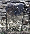
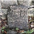
Old Boundary Marker by the C183, Alcombe Manor, Box parish
Estate Boundary Marker by the C183, in parish of Box (North Wiltshire District), Alcombe Manor, set in stone wall beside the Southwest side of the road.
To be surveyed
Milestone Society National ID: WI_BOX01em
Image: © Milestone Society
Taken: Unknown
0.11 miles
5
2008 : Steep hill near Alcombe
Follow the road to the right in Image] and you come to a steep hill, turn round half way up and you see this.
Lovely walking or cycling country if a little strenuous, but worth the effort.
OS Explorer maps 155 & 156 will help you plan your trip.
Image: © Maurice Pullin
Taken: 12 Feb 2008
0.11 miles
6
Old Boundary Marker north of Alcombe Manor, Box parish
Estate Boundary Marker by the C183, in parish of Box (North Wiltshire District), Alcombe Manor, set in stone wall on the West side of road.
To be surveyed
Milestone Society National ID: WI_BOX02em
Image: © Milestone Society
Taken: Unknown
0.15 miles