IMAGES TAKEN NEAR TO
Bradford Road, CORSHAM, SN13 0QY
Introduction
This page details the photographs taken nearby to Bradford Road, SN13 0QY by members of the Geograph project.
The Geograph project started in 2005 with the aim of publishing, organising and preserving representative images for every square kilometre of Great Britain, Ireland and the Isle of Man.

There are currently over 7.5m images from over14,400 individuals and you can help contribute to the project by visiting https://www.geograph.org.uk
Image Map (Loading...)


Getting Data...Please wait
Leaflet Map data © OpenStreetMap
Images are licensed for reuse under creativecommons.org/licenses/by-sa/2.0
Notes
- Clicking on the map will re-center to the selected point.
- The higher the marker number, the further away the image location is from the centre of the postcode.
Image Listing (4 Images Found)
Images are licensed for reuse under creativecommons.org/licenses/by-sa/2.0
Image
Details
Distance
1
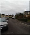
Highlands Close
This close is part of the small housing estate in Rudloe south of the A4.
Image: © HelenK
Taken: 9 Dec 2017
0.10 miles
2
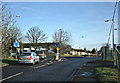
2008 : Fiveways Roundabout, Hawthorn near Rudloe
Fiveways is a twin mini-roundabout which needs care to negotiate especially at busy times.
The five ways are:
1. Bradford Road, the B3109 coming from Bradford on Avon behind the camera.
2. Continuation of Bradford Road almost straight ahead going to Rudloe and Corsham.
3. The minor road to the right for Westwells, Moor Green and Neston.
4 & 5. Boxfields Road and Leafy Lane, two minor roads exit left.
Image: © Maurice Pullin
Taken: 25 Feb 2008
0.20 miles
3
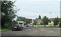
Mini-roundabout at Hawthorn
There are five roads converging at this point: the B3109; Boxfields Road; Westwells Road and Leafy Lane.
Image: © Stuart Logan
Taken: 13 Jul 2011
0.20 miles
4
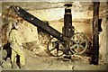
Box Mine Wilts
Crane Country. Intact crane in situ.
Image: © Nick Chipchase
Taken: 10 Mar 2000
0.25 miles