IMAGES TAKEN NEAR TO
Shrivenham Road, SWINDON, SN1 2NH
Introduction
This page details the photographs taken nearby to Shrivenham Road, SN1 2NH by members of the Geograph project.
The Geograph project started in 2005 with the aim of publishing, organising and preserving representative images for every square kilometre of Great Britain, Ireland and the Isle of Man.

There are currently over 7.5m images from over14,400 individuals and you can help contribute to the project by visiting https://www.geograph.org.uk
Image Map
Images are licensed for reuse under creativecommons.org/licenses/by-sa/2.0
Notes
- Clicking on the map will re-center to the selected point.
- The higher the marker number, the further away the image location is from the centre of the postcode.
Image Listing (98 Images Found)
Images are licensed for reuse under creativecommons.org/licenses/by-sa/2.0
Image
Details
Distance
1
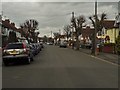
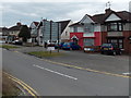
Shrivenham Road
c.1930s housing in Shrivenham Road. Earlier maps show the road pre-development as Stratton Road.
Image: © Ian Capper
Taken: 14 Jul 2022
0.03 miles
3
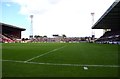
South side of the County Ground, Swindon
This is the home of Swindon Town Football Club. Viewed from the northern edge of the Magic Roundabout.
Image: © Jaggery
Taken: 14 Apr 2013
0.04 miles

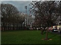
5
The Stratton Bank at the County Ground
Image: © Steve Daniels
Taken: 21 Aug 2011
0.06 miles
6
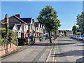
Shrivenham Road, Swindon
Shrivenham Road heads NE away from the Magic Roundabout.
Image: © Jaggery
Taken: 14 Apr 2013
0.07 miles
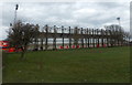
7
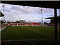
The Don Rodgers Stand at the County Ground
The County Ground is the home of Swindon Town.
Image: © Steve Daniels
Taken: 5 Feb 2017
0.07 miles
8
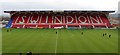
The Mecca; home to Swindon Town FC
Inside the County Ground on match day. STFC in red.. sticking 4 past Bournemouth playing in white!
Image: © Matthew Hatton
Taken: 22 Sep 2007
0.07 miles
9
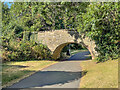
Route of Wilts and Berks Canal
Route of the former Wilts and Berks Canal, now a footpath linking Queen's Drive and Ocotal Way. The bridge is a former footpath bridge over the canal, dating from c.1810 and is grade II listed - see https://historicengland.org.uk/listing/the-list/list-entry/1355880?section=official-list-entry.
Image: © Ian Capper
Taken: 14 Jul 2022
0.07 miles