IMAGES TAKEN NEAR TO
Graham Street, SWINDON, SN1 2HA
Introduction
This page details the photographs taken nearby to Graham Street, SN1 2HA by members of the Geograph project.
The Geograph project started in 2005 with the aim of publishing, organising and preserving representative images for every square kilometre of Great Britain, Ireland and the Isle of Man.

There are currently over 7.5m images from over14,400 individuals and you can help contribute to the project by visiting https://www.geograph.org.uk
Image Map
Images are licensed for reuse under creativecommons.org/licenses/by-sa/2.0
Notes
- Clicking on the map will re-center to the selected point.
- The higher the marker number, the further away the image location is from the centre of the postcode.
Image Listing (148 Images Found)
Images are licensed for reuse under creativecommons.org/licenses/by-sa/2.0
Image
Details
Distance
1
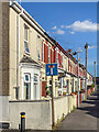
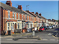
Graham Street
Early 20th Century terraced housing in Graham Street seen here from where it crosses Bathurst Road.
Image: © Ian Capper
Taken: 14 Jul 2022
0.02 miles
2
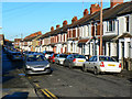
Graham Street, Swindon
The advertising hoarding at the far end is on the side of a building in York Road, beyond Fleming Way which was cut through in the 1960s.
Image: © Chris Brown
Taken: 21 Mar 2018
0.02 miles
3
Graham Street, Swindon
Graham Street is one of several similar streets dating to the Victorian era when there was a lot of residential development in what was called 'New Town' following the establishment of Brunel's Great Western Railway factory not far away.
Image: © Brian Robert Marshall
Taken: 20 Dec 2009
0.03 miles
4
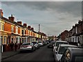
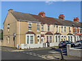
Rosebery Street, Swindon
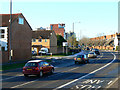
This is a view looking south. The street crossing from left to right along which the shoppers are walking is Bathurst Road. The southern gridline of the square is marked by the cars parked just beyond Bathurst Road. The trees in the background are on the far side of Fleming Way, one of the main routes into the town centre. Fleming Way is built on the line of the old Wilts and Berks canal which closed in the dim and distant past.
Image: © Brian Robert Marshall
Taken: 27 Sep 2008
0.03 miles
5
Old bridge abutments on Fleming Way
Fleming Way follows the alignment of the former Wilts and Berks Canal; this is where Graham Street crossed it by a bridge, explaining the level difference between this road and the side streets.
Image: © Stephen Craven
Taken: 14 Jul 2022
0.04 miles
6
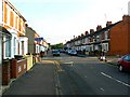
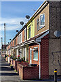
Roseberry Street
Early 20th Century terraced housing in Roseberry Street seen here from where it crosses Bathurst Road.
Image: © Ian Capper
Taken: 14 Jul 2022
0.04 miles
7
Graham Street
Early 20th Century terraced housing in Graham Street seen here from where it crosses Bathurst Road.
Image: © Ian Capper
Taken: 14 Jul 2022
0.04 miles
8
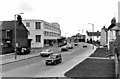
Fleming Way and the now demolished Garrard Factory
Fleming Way remains, though widened to provide for bus lanes on both sides, but the Garrard factory was demolished in the 1990's. At their peak, Garrard employed 4,500 people in this and two smaller factories. They originally derived from Garrards the Crown Jewellers. Later the record deck etc business in Swindon became independent, but were eventually taken over by Plessey, who used to be a big electronics manufacturer in the town. Finally the business was taken over by the Brazilian firm, Gradiente Electronica, and for the Swindon factory this coupled with the move over to compact discs acclerated its decline. By the time his photograph was taken in 1983, production here had ceased though apparently a few other staff were still based in the premises. Image; Image
In this picture can also be seen a Mini-traveller. Although these were made at Oxford, the Pressed Steel Company at Stratton (now the BMW Mini plant) used to supply the Oxford factory with body panels. Another two Mini's can be seen in this view:- Image
Image: © P L Chadwick
Taken: 18 Jan 1983
0.05 miles
9
Fleming Way and the Newcastle Street junction, Swindon
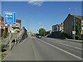
The viewpoint is approximately the same as that used by P L Chadwick in 1983 for this photograph Image and shows the changes that have occurred in the intervening twenty-six years. The gable end at the left shows that new windows have been installed and the back of the house painted. Its chimneys have gone. The newer houses opposite stand where the Garrards factory once did. PLC's photos shows a Mini the panels for which were made in Swindon. The car nearest the viewpoint in this one is a Honda, also built in the town. A Ford Mondeo occupies almost the same bit of road that a Ford Escort did back in 1983.
Image: © Brian Robert Marshall
Taken: 20 Dec 2009
0.05 miles
10
Newcastle Street
Early 20th Century terraced housing in Newcastle Street seen here from across Fleming Way. When the houses were originally built, Fleming Way did not exist, its route having previously been that of the Wilts and Berks Canal.
Image: © Ian Capper
Taken: 14 Jul 2022
0.06 miles