IMAGES TAKEN NEAR TO
Rosebery Street, SWINDON, SN1 2ES
Introduction
This page details the photographs taken nearby to Rosebery Street, SN1 2ES by members of the Geograph project.
The Geograph project started in 2005 with the aim of publishing, organising and preserving representative images for every square kilometre of Great Britain, Ireland and the Isle of Man.

There are currently over 7.5m images from over14,400 individuals and you can help contribute to the project by visiting https://www.geograph.org.uk
Image Map
Images are licensed for reuse under creativecommons.org/licenses/by-sa/2.0
Notes
- Clicking on the map will re-center to the selected point.
- The higher the marker number, the further away the image location is from the centre of the postcode.
Image Listing (139 Images Found)
Images are licensed for reuse under creativecommons.org/licenses/by-sa/2.0
Image
Details
Distance
1
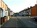
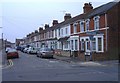
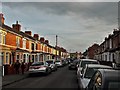
Rosebery Street, Swindon
This is a view looking south. The street crossing from left to right along which the shoppers are walking is Bathurst Road. The southern gridline of the square is marked by the cars parked just beyond Bathurst Road. The trees in the background are on the far side of Fleming Way, one of the main routes into the town centre. Fleming Way is built on the line of the old Wilts and Berks canal which closed in the dim and distant past.
Image: © Brian Robert Marshall
Taken: 27 Sep 2008
0.00 miles
2
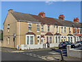
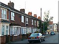
Roseberry Street
Early 20th Century terraced housing in Roseberry Street seen here from where it crosses Bathurst Road.
Image: © Ian Capper
Taken: 14 Jul 2022
0.01 miles
3
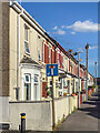
Graham Street
Early 20th Century terraced housing in Graham Street seen here from where it crosses Bathurst Road.
Image: © Ian Capper
Taken: 14 Jul 2022
0.02 miles
4
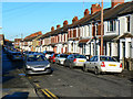
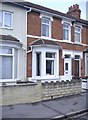
Graham Street, Swindon
Graham Street is one of several similar streets dating to the Victorian era when there was a lot of residential development in what was called 'New Town' following the establishment of Brunel's Great Western Railway factory not far away.
Image: © Brian Robert Marshall
Taken: 20 Dec 2009
0.03 miles
5
Graham Street
Early 20th Century terraced housing in Graham Street seen here from where it crosses Bathurst Road.
Image: © Ian Capper
Taken: 14 Jul 2022
0.03 miles
6
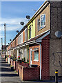
114 and 115 Rosebery Street, Swindon
On 20th October 1940, Swindon experienced its first night bombing. An unidentified bomber on a north-south line dropped three bombs, two high-explosive and one incendiary shortly after 22.00 hours. One of the bombs landed in Rosebery Street and destroyed or severely damaged numbers 115 to 120, on the western side of that street. Unfortunately the bomb caused a number of casualties. There were ten confirmed fatalities and an uncertain number of injured persons.
After the war was over the destroyed houses were replaced by new ones built to the same basic design but using different materials and along utilitarian lines. This image shows the houses as they are now and, although they will have been modernised in the intervening years, they remain noticeably different from their older neighbours. The bay windows lack the decorative stonework that graced the original houses and, although the current windows are PVCu, as rebuilt they would have been steel casements in place of the original timber sash windows.
In this image number 114, the house at the left, was not destroyed by the bomb and remains much as it would have looked when originally built about 100 years ago although the original timber sash windows have been replaced by PVCu and the flat roof over the bay has been changed to a pitched roof.
The house to the right is number 115 and is one of those which was rebuilt after the war.
Image: © Brian Robert Marshall
Taken: 27 Sep 2008
0.04 miles
7
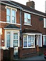
45 Rosebery Street, Swindon
Typical of the many Victorian and Edwardian terraced houses built during Swindon's railway boom.
Image: © Roger Cornfoot
Taken: 30 Mar 2007
0.04 miles
9
Graham Street, Swindon
The advertising hoarding at the far end is on the side of a building in York Road, beyond Fleming Way which was cut through in the 1960s.
Image: © Chris Brown
Taken: 21 Mar 2018
0.05 miles
10
115 to 120 Rosebery Street, Swindon
In contrast to many other towns and cities in the UK such as Bath, Bristol, Coventry, Exeter and of course London, Swindon largely escaped the attentions of Hitler’s Luftwaffe between the years of 1939 and 1945, largely but not completely. During those years, occasional attacks took place, usually by isolated raiders. In the intervening years all the significant destruction that was caused has been repaired. However, there is still evidence of what happened in those troubled times and the legacy remains in the form of houses that were rebuilt after the war in a style that is similar to but distinct from the originals.
On 20th October 1940, Swindon experienced its first night bombing. An unidentified bomber on a north-south line dropped three bombs, two high-explosive and one incendiary shortly after 22.00 hours. One of the bombs landed in Rosebery Street and destroyed or severely damaged numbers 115 to 120, on the western side of that street. Unfortunately the bomb caused a number of casualties. There were ten confirmed fatalities and an uncertain number of injured persons.
After the war was over the destroyed houses were replaced by new ones built to the same basic design but using different materials and along utilitarian lines. This image shows the houses as they are now and, although they will have been modernised in the intervening years, they remain noticeably different from their older neighbours. The bay windows lack the decorative stonework that graced the original houses and, although the current windows are PVCu, as rebuilt they would have been steel casements in place of the original timber sash windows.
The historical information above was extracted from a monograph ‘Swindon Air Raids in World War 2’ by K Walter published privately in 1998, a copy of which can be found in Swindon’s Central Library.
Image: © Brian Robert Marshall
Taken: 27 Sep 2008
0.05 miles