IMAGES TAKEN NEAR TO
Folly Lane, MELKSHAM, SN12 8EZ
Introduction
This page details the photographs taken nearby to Folly Lane, SN12 8EZ by members of the Geograph project.
The Geograph project started in 2005 with the aim of publishing, organising and preserving representative images for every square kilometre of Great Britain, Ireland and the Isle of Man.

There are currently over 7.5m images from over14,400 individuals and you can help contribute to the project by visiting https://www.geograph.org.uk
Image Map
Images are licensed for reuse under creativecommons.org/licenses/by-sa/2.0
Notes
- Clicking on the map will re-center to the selected point.
- The higher the marker number, the further away the image location is from the centre of the postcode.
Image Listing (12 Images Found)
Images are licensed for reuse under creativecommons.org/licenses/by-sa/2.0
Image
Details
Distance
1
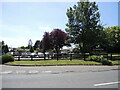
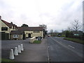
Lowden garden centre
The centre was founded by a single farmer in the early 1980s in Chippenham but moved here in 1987. It has since expanded again and now offers food, drink and an events marquee too.
Image: © Neil Owen
Taken: 15 Jun 2021
0.03 miles
2
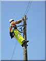
Taking the high line
A telephone engineer makes some repairs at the top level.
Image: © Neil Owen
Taken: 15 Jun 2021
0.03 miles
3
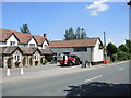
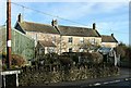
Food on Folly Lane
The old Golden Fleece had served for over a century, but it is now better known as Il Vello d'Oro - an Italian ristorante based on the premises.
Image: © Neil Owen
Taken: 15 Jun 2021
0.03 miles
4
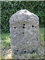
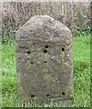
Folly Lane's faceless stone
As with many such milestones, the vital piece of ironmongery is missing. In the day it would have informed travellers that they were ten miles from Bath. See Image] for a location view.
Image: © Neil Owen
Taken: 15 Jun 2021
0.04 miles
5
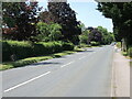
A365 near Atworth
A view looking east along the A365 towards Shaw. The Golden Fleece public house is on the left, with the entrance to the Lowden Garden Centre to the right.
Image: © Phil Williams
Taken: 27 Jan 2006
0.05 miles
6
2008 : Cottages on Folly Lane
Folly Lane is about half way between Atworth and Shaw and forms a small section of the A365.
Image: © Maurice Pullin
Taken: 4 Feb 2008
0.05 miles
7
Along the A365 Folly Lane
Looking westwards towards Atworth: at the left of shot in the shadows is a milestone. See Image] for a closer look.
Image: © Neil Owen
Taken: 15 Jun 2021
0.05 miles
8
Old Milestone by the A365, Folly Lane, Shaw
Stone post (plate lost) by the A365, in parish of Broughton Gifford (West Wiltshire District), Shaw; 65m East of garden centre, on the verge, on South side of road. Melksham plate, erected by the Melksham turnpike trust in the 19th century.
Inscription once read:-
(BATH)
(10)
Milestone Society National ID: WI_LB_BADZ10
Image: © M Faherty
Taken: 1 Jan 2008
0.07 miles
9
Old Boundary Marker by the A365, Bath Road, Pie Corner
Parish Boundary Marker by the A365, in parish of Melksham Without (West Wiltshire District), North side of road, opposite Pie Corner, against dry stone wall.
Out of place - in public view
Inscription reads:-
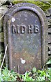
MDHB
Milestone Society National ID: WI_MELW01pb
Image: © Milestone Society
Taken: Unknown
0.09 miles
10
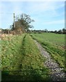
2008 : Between Atworth and Shaw
The track leads to the local sewage works then on to Whitley Farm. This does not accord with OS Explorer 156 but can be confirmed in Google Earth.
Image: © Maurice Pullin
Taken: 4 Feb 2008
0.17 miles