IMAGES TAKEN NEAR TO
Verbena Court, MELKSHAM, SN12 7GS
Introduction
This page details the photographs taken nearby to Verbena Court, SN12 7GS by members of the Geograph project.
The Geograph project started in 2005 with the aim of publishing, organising and preserving representative images for every square kilometre of Great Britain, Ireland and the Isle of Man.

There are currently over 7.5m images from over14,400 individuals and you can help contribute to the project by visiting https://www.geograph.org.uk
Image Map
Images are licensed for reuse under creativecommons.org/licenses/by-sa/2.0
Notes
- Clicking on the map will re-center to the selected point.
- The higher the marker number, the further away the image location is from the centre of the postcode.
Image Listing (17 Images Found)
Images are licensed for reuse under creativecommons.org/licenses/by-sa/2.0
Image
Details
Distance
1
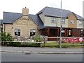
New public house
A recently built public house in an area just off the new Eastern Way with a small supermarket and several other shops.
There has been a great deal of development to the east of Melksham in recent years with some 2,000 new homes built or planned by 2026.
Image: © Michael Dibb
Taken: 8 Jul 2017
0.05 miles
2
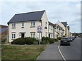
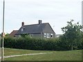
New houses on Cranesbill Road
The bland featureless new houses on Cranesbill Road, just off the new Eastern Way.
There has been a great deal of development to the east of Melksham in recent years with some 2,000 new homes built or planned by 2026.
Image: © Michael Dibb
Taken: 8 Jul 2017
0.05 miles
3
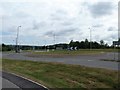
Eastern Way
The new road presently marks the eastern edge of the town.
There has been a great deal of development to the east of Melksham in recent years with some 2,000 new homes built or planned by 2026.
Image: © Michael Dibb
Taken: 8 Jul 2017
0.07 miles
5
Snarlton Farm Cottages
Seen from Eastern Way.
Image: © Michael Dibb
Taken: 8 Jul 2017
0.11 miles
6
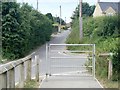
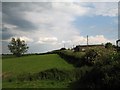
Snarlton Lane
Until recently Snarlton Lane was the only road in the area. It led from the A3102 road to Snarlton Farm and the continued to Redstocks as a bridleway. Now it has been blocked off at Eastern Way.
Image: © Michael Dibb
Taken: 8 Jul 2017
0.11 miles
7
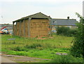
2008 : Barn at Snarlton Farm
Tom Stainer, Snarlton Farm, Melksham, Wiltshire
"We have used sexed semen on our heifers for the last 18 months, and have been very pleased with the outcome. As a result we will be using sexed semen on our cows next year. I initially started using sexed semen because of my poor ratio of bull to heifer calves, we are now seeing the benefits of ABS Sexation, as our heifer numbers have increased dramatically."
The above was copied from: http://search.msn.co.uk/results.aspx?q=Snarlton+Farm&FORM=MSNH&mkt=en-gb&rf=1
Image: © Maurice Pullin
Taken: 16 Sep 2008
0.13 miles
8
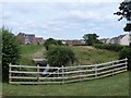
Snarlton Farm
The farm is seen from Eastern Way.
Image: © Michael Dibb
Taken: 8 Jul 2017
0.14 miles
9
Green corridor
Clackers Brook creates a corridor of green through the bland modern housing.
There has been a great deal of development to the east of Melksham in recent years with some 2,000 new homes built or planned by 2026.
Image: © Michael Dibb
Taken: 8 Jul 2017
0.15 miles
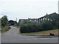
10
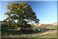
View along the old field boundary towards The Gateway
The trees and remains of the old field boundary now separate the existing houses which have been built since 2009 from the new build of the third phase of development of this housing estate which is still under construction in 2012.
Image: © Doug Lee
Taken: 11 Nov 2012
0.15 miles