IMAGES TAKEN NEAR TO
Linnet Lane, MELKSHAM, SN12 7FA
Introduction
This page details the photographs taken nearby to Linnet Lane, SN12 7FA by members of the Geograph project.
The Geograph project started in 2005 with the aim of publishing, organising and preserving representative images for every square kilometre of Great Britain, Ireland and the Isle of Man.

There are currently over 7.5m images from over14,400 individuals and you can help contribute to the project by visiting https://www.geograph.org.uk
Image Map
Images are licensed for reuse under creativecommons.org/licenses/by-sa/2.0
Notes
- Clicking on the map will re-center to the selected point.
- The higher the marker number, the further away the image location is from the centre of the postcode.
Image Listing (11 Images Found)
Images are licensed for reuse under creativecommons.org/licenses/by-sa/2.0
Image
Details
Distance
1
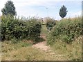
Towards the road
The footpath comes to Eastern Way, the new road currently delimiting the eastern edge of Melksham. The footpath continues on the far side of Eastern Way as a series of passageways amongst the bland modern housing estate.
Image: © Michael Dibb
Taken: 8 Jul 2017
0.11 miles
2
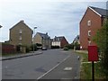
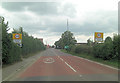
Skylark Road
Some of the bland modern housing at the eastern edge of Melksham.
There has been a great deal of development to the east of Melksham in recent years with some 2,000 new homes built or planned by 2026.
Image: © Michael Dibb
Taken: 8 Jul 2017
0.12 miles
3
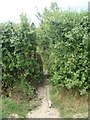
It is a squeeze
The footpath passes into the next field via this squeeze stile.
Image: © Michael Dibb
Taken: 8 Jul 2017
0.14 miles
4
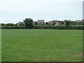
Green field, new houses
The footpath runs diagonally across this field with the newly built houses on the eastern edge of Melksham in the background.
There has been a great deal of development to the east of Melksham in recent years with some 2,000 new homes built or planned by 2026.
Image: © Michael Dibb
Taken: 8 Jul 2017
0.15 miles
5
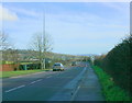
2009 : The A3102 as it leaves Melksham
And do watch out for the speed cameras.
Roundway Hill near Devizes is visible on the skyline with Oliver's Castle Image to the left.
Image: © Maurice Pullin
Taken: 20 Jan 2009
0.18 miles
6
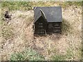
Very small house
By the side of Easter Way is this curious object. There is the cover of an underground valve for the water supply just in front of the house so possibly it has something to do with that.
Image: © Michael Dibb
Taken: 8 Jul 2017
0.19 miles
7
A3102 enters Melksham
A small Wiltshire town that is somewhat overwhelmed by new development.
Image: © Stuart Logan
Taken: 13 Jul 2011
0.21 miles
8
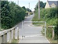
Snarlton Lane
Until recently Snarlton Lane was the only road in the area. It led from the A3102 road to Snarlton Farm and the continued to Redstocks as a bridleway. Now it has been blocked off at Eastern Way.
Image: © Michael Dibb
Taken: 8 Jul 2017
0.21 miles
9
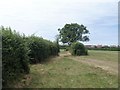
Change sides
The footpath changes to the opposite side of the hedgerow. The new house on the eastern edge of Melksham are seen in the distance.
There has been a great deal of development to the east of Melksham in recent years with some 2,000 new homes built or planned by 2026.
Image: © Michael Dibb
Taken: 8 Jul 2017
0.23 miles
10

New Rd.
View north along New Rd. It runs north from Sandridge Common to Woodrow Rd just on the north west outskirts of Melksham. This is the junction with Sandridge Common.
Image: © Nigel Mykura
Taken: 15 Jun 2010
0.24 miles