
IMAGES TAKEN NEAR TO
Mallory Place, MELKSHAM, SN12 6YB
Introduction
This page details the photographs taken nearby to Mallory Place, SN12 6YB by members of the Geograph project.
The Geograph project started in 2005 with the aim of publishing, organising and preserving representative images for every square kilometre of Great Britain, Ireland and the Isle of Man.

There are currently over 7.5m images from over14,400 individuals and you can help contribute to the project by visiting https://www.geograph.org.uk
Image Map
Images are licensed for reuse under creativecommons.org/licenses/by-sa/2.0
Notes
- Clicking on the map will re-center to the selected point.
- The higher the marker number, the further away the image location is from the centre of the postcode.
Image Listing (21 Images Found)
Images are licensed for reuse under creativecommons.org/licenses/by-sa/2.0
Image
Details
Distance
1
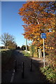
End of the cycleway at the Spa
The cycleway runs along the pavement from Melksham Oak school to end here on Spa Road.
Image: © Doug Lee
Taken: 11 Nov 2012
0.10 miles
2
![Once the main road [1]](https://s3.geograph.org.uk/geophotos/05/66/13/5661359_46cdcdc9_120x120.jpg)
Once the main road [1]
Once part of the A365 road, this short stretch has been bypassed and the main road now runs to a large roundabout. Seen here looking south east towards Devizes.
Image: © Michael Dibb
Taken: 12 Jan 2018
0.11 miles
3
![Bowerhill houses [2]](https://s3.geograph.org.uk/geophotos/05/79/65/5796555_f23447d7_120x120.jpg)
Bowerhill houses [2]
Bowerhill is effectively a small satellite town of Melksham. This area of Bowerhill was developed in the mid 1990s.
Image: © Michael Dibb
Taken: 20 May 2018
0.11 miles
4
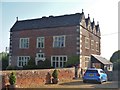
Woolmore Manor
Originally built in 1631 for George Hulbert, a London vintner, this magnificent house became a farmhouse. The house is thought to have been built to a plan by Inigo Jones. Listed, grade II*, with details at: https://www.historicengland.org.uk/listing/the-list/list-entry/1021762
Image: © Michael Dibb
Taken: 20 May 2018
0.12 miles
5
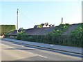
An interesting roof line
This long farm building alongside the road has a good collection of dips and a good covering of greenery. The building is part of Woolmore Farm which at this date was up for sale. See Image and Image
Image: © Michael Dibb
Taken: 20 May 2018
0.13 miles
6
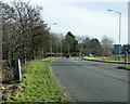
2009 : Roundabout at the eastern end of the Melksham bypass
There are people who don't like bypasses and climb trees and things to stop them being built, I'm not keen on them either but they make a big difference to life in places like Melksham.
We are looking out along the A365 to Sells Green and Martinslade where it joins the A361.
Image: © Maurice Pullin
Taken: 20 Jan 2009
0.15 miles
7
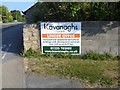
For sale
Image: © Michael Dibb
Taken: 20 May 2018
0.15 miles
8
![Bath Road houses [1]](https://s2.geograph.org.uk/geophotos/05/66/13/5661382_ed4524fd_120x120.jpg)
Bath Road houses [1]
Numbers 403 and 404 Bath Road, a pair of semi-detached houses built circa 1815 as part of a short lived spa development. Listed, grade II, with details at: https://www.historicengland.org.uk/listing/the-list/list-entry/1194754
Image: © Michael Dibb
Taken: 12 Jan 2018
0.15 miles
9
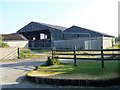
Woolmore Farm
Image: © Michael Dibb
Taken: 20 May 2018
0.16 miles
10
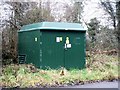
Enclosed sub station
The small enclosed sub station is a recent addition to Bath Road.
Image: © Michael Dibb
Taken: 12 Jan 2018
0.16 miles