IMAGES TAKEN NEAR TO
SN12 6GJ
Introduction
This page details the photographs taken nearby to SN12 6GJ by members of the Geograph project.
The Geograph project started in 2005 with the aim of publishing, organising and preserving representative images for every square kilometre of Great Britain, Ireland and the Isle of Man.

There are currently over 7.5m images from over14,400 individuals and you can help contribute to the project by visiting https://www.geograph.org.uk
Image Map
Images are licensed for reuse under creativecommons.org/licenses/by-sa/2.0
Notes
- Clicking on the map will re-center to the selected point.
- The higher the marker number, the further away the image location is from the centre of the postcode.
Image Listing (258 Images Found)
Images are licensed for reuse under creativecommons.org/licenses/by-sa/2.0
Image
Details
Distance
1
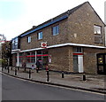
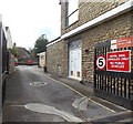
Melksham Post Office
The post office is at 31 Church Street. The entrance http://www.geograph.org.uk/photo/4233936 to Melksham Delivery Office is on the left.
Image: © Jaggery
Taken: 5 Nov 2014
0.00 miles
2
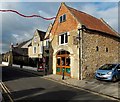
Tourist Information Centre in Melksham
Located at 32 Church Street near a parking area and the post office. A range of services are available here, as well as attractions brochures and souvenirs. Often, tickets for events are available at discounted prices. The Centre can help with booking coaches and local accommodation.
Image: © Jaggery
Taken: 5 Nov 2014
0.01 miles
3
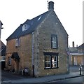
26 Church Street
This 18th century detached cottage is now a restaurant. Listed, grade II, with details at: https://www.historicengland.org.uk/listing/the-list/list-entry/1286110
Image: © Michael Dibb
Taken: 20 May 2018
0.01 miles
4

Church Street, Melksham
Leading to Church Walk.
Image: © Roger Cornfoot
Taken: 3 Feb 2007
0.01 miles
5
Electricity substation at the edge of Melksham Post Office
Viewed across Church Street. The edge of the post office http://www.geograph.org.uk/photo/4233885 is on the left. The yellow identifier at the entrance to the SSE Power Distribution electricity substation is GPO Melksham S/S No 2122759.
The numbers are in a tiny text font below their representation in barcode format.
Image: © Jaggery
Taken: 5 Nov 2014
0.01 miles
6

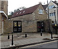
Former warehouse
Probably associated with the wollen trade, this late 18th century building is now the tourist information centre.
Image: © Michael Dibb
Taken: 20 May 2018
0.01 miles
7
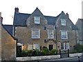
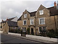
34 & 36 Church Street
This late 17th/early 18th century detached house is now two dwellings. Listed (as 34 & 34A), grade II, with details at https://www.historicengland.org.uk/listing/the-list/list-entry/1286072
Image: © Michael Dibb
Taken: 20 May 2018
0.01 miles
8
Mulberry Cottage, Melksham
Built c1700 as a detached house in Church Street. Now (2014) two residences, number 34 (Mulberry Cottage) on the right and the smaller number 36 on the left. The building was Grade II listed in 1950.
Image: © Jaggery
Taken: 5 Nov 2014
0.01 miles
9
Entrance to Melksham Delivery Office
From Church Street. The entrance is at the edge of the post office. http://www.geograph.org.uk/photo/4233885
Image: © Jaggery
Taken: 5 Nov 2014
0.01 miles
10

Church Street garden
A small public garden off Church Street.
Image: © Michael Dibb
Taken: 20 May 2018
0.01 miles