IMAGES TAKEN NEAR TO
Haydon Street, SWINDON, SN1 1DT
Introduction
This page details the photographs taken nearby to Haydon Street, SN1 1DT by members of the Geograph project.
The Geograph project started in 2005 with the aim of publishing, organising and preserving representative images for every square kilometre of Great Britain, Ireland and the Isle of Man.

There are currently over 7.5m images from over14,400 individuals and you can help contribute to the project by visiting https://www.geograph.org.uk
Image Map
Images are licensed for reuse under creativecommons.org/licenses/by-sa/2.0
Notes
- Clicking on the map will re-center to the selected point.
- The higher the marker number, the further away the image location is from the centre of the postcode.
Image Listing (480 Images Found)
Images are licensed for reuse under creativecommons.org/licenses/by-sa/2.0
Image
Details
Distance
1
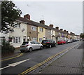
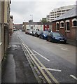
On-street parking, Haydon Street, Swindon
A row of parked cars on the north side of the street contrasts with
the south side where double yellow lines indicate no parking at any time.
The white arrow painted on the road surface shows the direction of travel on this one-way street.
Image: © Jaggery
Taken: 3 Sep 2017
0.01 miles
2
One way except cycles sign on a Swindon corner
The sign alongside Haydon Street points left along Alexandra Road. http://www.geograph.org.uk/photo/5526821
Image: © Jaggery
Taken: 3 Sep 2017
0.02 miles
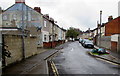
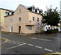
3
Haydon Street, Swindon
Viewed across Aylesbury Street.
Image: © Jaggery
Taken: 3 Sep 2017
0.02 miles
4
Alexandra Road, Swindon
From Station Road along Alexandra Road towards Haydon Street viewed in early September 2017.
The faded, or perhaps defaced, mural on the left was painted in 1979. It depicts a street scene outside Swindon Junction railway station at the start of the 20th century. Swindon Junction was the name of the present-day Swindon railway station from its opening in 1842 until 1961, when Swindon Town station closed.
Image: © Jaggery
Taken: 3 Sep 2017
0.02 miles
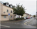
5
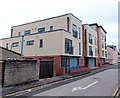
Recently-built flats, Aylesbury Street, Swindon
Viewed from the Station Road end looking towards Haydon Street.
Image: © Jaggery
Taken: 14 Apr 2013
0.03 miles
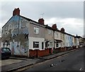
6
Houses on the corner of Haydon Street and Aylesbury Street, Swindon
The two front doors are on the Aylesbury Street side of the corner.
Image: © Jaggery
Taken: 3 Sep 2017
0.03 miles
7
Alexandra Road, Swindon
Houses on the east side of the street, viewed from the Station Road end.
The faded, or perhaps defaced, mural was painted in 1979. It depicts a street scene outside Swindon Junction railway station at the start of the 20th century.
Swindon Junction was the name of the present-day Swindon railway station from its opening in 1842 until 1961, when Swindon Town station closed.
Image: © Jaggery
Taken: 14 Apr 2013
0.03 miles
8
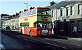
Mobile Advert on Manchester Road
A Thamesdown Transport bus makes its way along Manchester Road, Swindon, in harsh spring sunshine. Many of the roads in the area carry the names of places served by the GWR (Gods Wonderful Railway as it is sometimes jokingly called). In the background, beyond the line of terraced houses, one of the office blocks on Milford Street can be seen.
The vehicle is a Leyland Fleetline with Eastern Coachworks body.
Image: © Martin Addison
Taken: Unknown
0.03 miles
9
Aylesbury Street, Swindon
From Station Road along Aylesbury Street towards Haydon Street.
Image: © Jaggery
Taken: 3 Sep 2017
0.03 miles
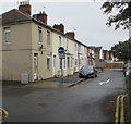
10
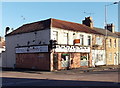
Ming Dynasty, Swindon
Chinese restaurant and takeaway on the corner of Manchester Road and Aylesbury Street,
opposite the entrance to Swindon Bus Station. http://www.geograph.org.uk/photo/3318004
Image: © Jaggery
Taken: 2 Feb 2013
0.03 miles