IMAGES TAKEN NEAR TO
Studley Corner, CALNE, SN11 9NJ
Introduction
This page details the photographs taken nearby to Studley Corner, SN11 9NJ by members of the Geograph project.
The Geograph project started in 2005 with the aim of publishing, organising and preserving representative images for every square kilometre of Great Britain, Ireland and the Isle of Man.

There are currently over 7.5m images from over14,400 individuals and you can help contribute to the project by visiting https://www.geograph.org.uk
Image Map
Images are licensed for reuse under creativecommons.org/licenses/by-sa/2.0
Notes
- Clicking on the map will re-center to the selected point.
- The higher the marker number, the further away the image location is from the centre of the postcode.
Image Listing (7 Images Found)
Images are licensed for reuse under creativecommons.org/licenses/by-sa/2.0
Image
Details
Distance
1
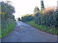
Start of footpath
From Studley Hill, this lane leads to a footpath that runs to the A4 and on to Church Street, Derry Hill.
Image: © Michael Dibb
Taken: 6 Dec 2014
0.03 miles
2
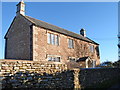
Top Farmhouse
Seemingly no longer a farmhouse as some of what was possibly the farmyard has been developed for residential accommodation. The early 19th century farmhouse is listed, grade II, details are at http://list.english-heritage.org.uk/resultsingle.aspx?uid=1261284
Image: © Michael Dibb
Taken: 6 Dec 2014
0.09 miles
3
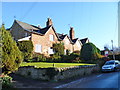
Cottages at Studley Hill
These four attractive cottages are located on the steepest part of Studley Hill. The sun had not, as yet, reached the road (as can be seen by the ice visible at the side of the road) and it was slippery.
Image: © Michael Dibb
Taken: 6 Dec 2014
0.10 miles
4
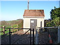
Studley Pumping Station
Located in Studley Hill.
Image: © Michael Dibb
Taken: 6 Dec 2014
0.12 miles
5
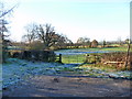
Start of footpath
From the lower slopes of Studley Hill a footpath leaves heading towards the A4 at the foot of Old Derry Hill. The way is not through the gate but along the hedge side at the left of the image.
Image: © Michael Dibb
Taken: 6 Dec 2014
0.23 miles
6
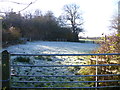
Across the frosty field
After leaving Studley Hill, the footpath crosses a frosty field. The path runs just to the right of the large tree in the image. The woodland is named Close Wood.
Image: © Michael Dibb
Taken: 6 Dec 2014
0.23 miles
7
![Alongside the wood [1]](https://s2.geograph.org.uk/geophotos/04/27/19/4271906_b617c795_120x120.jpg)
Alongside the wood [1]
After crossing the frosty field Image, the path runs alongside Close Wood.
Image: © Michael Dibb
Taken: 6 Dec 2014
0.24 miles