IMAGES TAKEN NEAR TO
Studley, CALNE, SN11 9LL
Introduction
This page details the photographs taken nearby to SN11 9LL by members of the Geograph project.
The Geograph project started in 2005 with the aim of publishing, organising and preserving representative images for every square kilometre of Great Britain, Ireland and the Isle of Man.

There are currently over 7.5m images from over14,400 individuals and you can help contribute to the project by visiting https://www.geograph.org.uk
Image Map
Images are licensed for reuse under creativecommons.org/licenses/by-sa/2.0
Notes
- Clicking on the map will re-center to the selected point.
- The higher the marker number, the further away the image location is from the centre of the postcode.
Image Listing (8 Images Found)
Images are licensed for reuse under creativecommons.org/licenses/by-sa/2.0
Image
Details
Distance
1
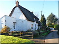
Greenstead
This 17th century thatched cottage in Norley Lane is listed, grade II, and details are at http://list.english-heritage.org.uk/resultsingle.aspx?uid=1239928
Image: © Michael Dibb
Taken: 6 Dec 2014
0.04 miles
2
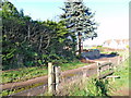
End of path
The footpath from the A4 ends here where it meets the drive to the house called Mayfield.
Image: © Michael Dibb
Taken: 6 Dec 2014
0.05 miles
3
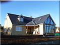
New house
This house is nearing completion. The large windows will make the most of the view.
Image: © Michael Dibb
Taken: 6 Dec 2014
0.05 miles
5
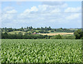
2009 : Maize field behind the Soho Inn
Looking due north. The hills are north of the River Marden.
Image: © Maurice Pullin
Taken: 14 Jul 2009
0.20 miles
6
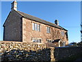
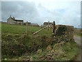
Top Farmhouse
Seemingly no longer a farmhouse as some of what was possibly the farmyard has been developed for residential accommodation. The early 19th century farmhouse is listed, grade II, details are at http://list.english-heritage.org.uk/resultsingle.aspx?uid=1261284
Image: © Michael Dibb
Taken: 6 Dec 2014
0.21 miles
7
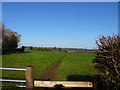
Path to Studley
From the A4 road, the path runs across the fields towards Studley.
Image: © Michael Dibb
Taken: 6 Dec 2014
0.24 miles
8
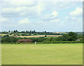
2009 : Playing field, Derry Hill Cricket and Football Club
Looking north from the entrance on the A4.
The house to the left is in Studley with Studley House Farm behind.
Further over and to the right we see farmland around Bremhill.
Image: © Maurice Pullin
Taken: 14 Jul 2009
0.25 miles