IMAGES TAKEN NEAR TO
Ratford Hill, CALNE, SN11 9JY
Introduction
This page details the photographs taken nearby to Ratford Hill, SN11 9JY by members of the Geograph project.
The Geograph project started in 2005 with the aim of publishing, organising and preserving representative images for every square kilometre of Great Britain, Ireland and the Isle of Man.

There are currently over 7.5m images from over14,400 individuals and you can help contribute to the project by visiting https://www.geograph.org.uk
Image Map
Images are licensed for reuse under creativecommons.org/licenses/by-sa/2.0
Notes
- Clicking on the map will re-center to the selected point.
- The higher the marker number, the further away the image location is from the centre of the postcode.
Image Listing (8 Images Found)
Images are licensed for reuse under creativecommons.org/licenses/by-sa/2.0
Image
Details
Distance
1
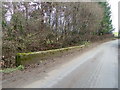
Ratford Bridge, Ratford
The bridge takes the minor road over the River Marden. There in an Ordnance Survey bench mark on the parapet.
Image: © Maigheach-gheal
Taken: 1 Jan 2011
0.07 miles
2
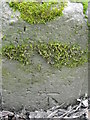
Bench Mark, Ratford Bridge
The bench mark is on the bridge parapet. For a wider view Image and for further information on the bench mark http://www.bench-marks.org.uk/bm36429
Image: © Maigheach-gheal
Taken: 1 Jan 2011
0.07 miles
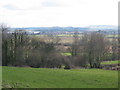
5
![A walk around Calne [24]](https://s1.geograph.org.uk/geophotos/06/76/29/6762913_b7843d3f_120x120.jpg)
A walk around Calne [24]
From the footpath is this view looking into the valley of Cowage Brook with a fine tree.
From the town centre the route leads through mostly modern housing before meeting open countryside after crossing the recently built A3102. After passing Calne Sewage Works and crossing both the abandoned Wilts and Berks canal and the River Marden the route joins the dismantled Calne Branch railway which is followed back to the town centre where it crosses the canal again. About 3½ miles.
Image: © Michael Dibb
Taken: 7 Oct 2020
0.20 miles
6
![A walk around Calne [23]](https://s3.geograph.org.uk/geophotos/06/76/29/6762911_eab9f2cf_120x120.jpg)
A walk around Calne [23]
The footpath leaves the minor road through this stile alongside the gate.
From the town centre the route leads through mostly modern housing before meeting open countryside after crossing the recently built A3102. After passing Calne Sewage Works and crossing both the abandoned Wilts and Berks canal and the River Marden the route joins the dismantled Calne Branch railway which is followed back to the town centre where it crosses the canal again. About 3½ miles.
Image: © Michael Dibb
Taken: 7 Oct 2020
0.21 miles
7
Bremhill View from Bremhill
This view is the footpath from the Dumb Post Inn to Bremhill Church, and looks right out to Cherhill White Horse. Calne draws ever near.
Image: © Ben Croft
Taken: 3 Mar 2005
0.23 miles
8
![A walk around Calne [25]](https://s2.geograph.org.uk/geophotos/06/76/29/6762914_187936de_120x120.jpg)
A walk around Calne [25]
The footpath runs along the rough track.
From the town centre the route leads through mostly modern housing before meeting open countryside after crossing the recently built A3102. After passing Calne Sewage Works and crossing both the abandoned Wilts and Berks canal and the River Marden the route joins the dismantled Calne Branch railway which is followed back to the town centre where it crosses the canal again. About 3½ miles.
Image: © Michael Dibb
Taken: 7 Oct 2020
0.24 miles