IMAGES TAKEN NEAR TO
Goatacre, CALNE, SN11 9HY
Introduction
This page details the photographs taken nearby to SN11 9HY by members of the Geograph project.
The Geograph project started in 2005 with the aim of publishing, organising and preserving representative images for every square kilometre of Great Britain, Ireland and the Isle of Man.

There are currently over 7.5m images from over14,400 individuals and you can help contribute to the project by visiting https://www.geograph.org.uk
Image Map
Images are licensed for reuse under creativecommons.org/licenses/by-sa/2.0
Notes
- Clicking on the map will re-center to the selected point.
- The higher the marker number, the further away the image location is from the centre of the postcode.
Image Listing (26 Images Found)
Images are licensed for reuse under creativecommons.org/licenses/by-sa/2.0
Image
Details
Distance
1
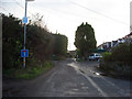
Goatacre Lane
Goatacre Lane southwards from its junction with Combe Lane.
Image: © Vieve Forward
Taken: 27 Dec 2014
0.01 miles
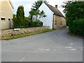
2
Goatacre Lane, Goatacre
The lane continues to the south-east until you can't drive any further. The eastern extremity is known as Lower Goatacre.
Image: © Brian Robert Marshall
Taken: 10 Jun 2008
0.05 miles
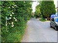
3
Combe Lane, Goatacre
Combe Lane leads west away from the viewpoint in Goatacre Lane towards the A3102 road between Lyneham and Calne.
Image: © Brian Robert Marshall
Taken: 10 Jun 2008
0.06 miles
4
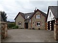
Recent built
Set in the junction of Goatacre Lane and Combe Lane.
Image: © Michael Dibb
Taken: 17 Apr 2017
0.07 miles
5
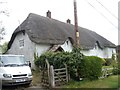
Longridge Cottage
This 17th century thatched cottage is listed, grade II, with details at: https://www.historicengland.org.uk/listing/the-list/list-entry/1022497
Image: © Michael Dibb
Taken: 17 Apr 2017
0.08 miles
6
![Multipurpose field [2]](https://s2.geograph.org.uk/geophotos/05/36/32/5363218_a7e24e3e_120x120.jpg)
Multipurpose field [2]
This field at the side of Combe Lane is truly all purpose. It holds a pavilion, a cricket pitch, two football pitches, portacabins, pigs, picnic tables and a great quantity of farm machinery and equipment.
Image: © Michael Dibb
Taken: 17 Apr 2017
0.13 miles
7
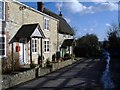
Goatacre
Cottages line the main street, in this small village, south of Lyneham.
Image: © Roger Cornfoot
Taken: 21 Jan 2007
0.13 miles
8
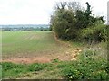
Field edge way
A public footpath runs up along the edge of the field and meets another footpath which runs along the drive to Lower Littlecott Farm.
Image: © Michael Dibb
Taken: 17 Apr 2017
0.13 miles
9
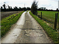
Footpath to Goatacre
The footpath here benefits from sharing its route with a reasonably well surfaced farm track on this section of it.
Image: © Brian Robert Marshall
Taken: 2 Mar 2009
0.14 miles
10
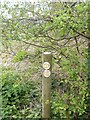
Three ways to go
This post carries three public footpath signs.
Image: © Michael Dibb
Taken: 17 Apr 2017
0.14 miles