IMAGES TAKEN NEAR TO
Maiden Lane, CALNE, SN11 8UZ
Introduction
This page details the photographs taken nearby to Maiden Lane, SN11 8UZ by members of the Geograph project.
The Geograph project started in 2005 with the aim of publishing, organising and preserving representative images for every square kilometre of Great Britain, Ireland and the Isle of Man.

There are currently over 7.5m images from over14,400 individuals and you can help contribute to the project by visiting https://www.geograph.org.uk
Image Map
Images are licensed for reuse under creativecommons.org/licenses/by-sa/2.0
Notes
- Clicking on the map will re-center to the selected point.
- The higher the marker number, the further away the image location is from the centre of the postcode.
Image Listing (51 Images Found)
Images are licensed for reuse under creativecommons.org/licenses/by-sa/2.0
Image
Details
Distance
1
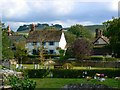
View south from the Church of St James, Cherhill
Cherhill is a compact but elongated village just north of the A4 between Calne and Beckhampton. It has a recorded history as far back as 1377. In more recent years its population has risen and fallen in line with the histories of the now-extinct RAF bases at Compton Bassett and Yatesbury. In 1918 the Co-operative Wholesale Society purchased the estate that included Cherhill. Anecdotal evidence is that the CWS couldn't make their holdings of around 4600 acres pay and sold the lot in 1929-1930. Tenants of the various cottages were able to purchase the freeholds at a discount and many of them did it seems. Much more here http://history.wiltshire.gov.uk/community/getcom.php?id=50
Image: © Brian Robert Marshall
Taken: 24 Aug 2011
0.08 miles
2
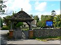
Lych gate, Church of St James, Cherhill
The lych gate is surprisingly modern. A wooden plaque within asserts that it was built in 1990 in memory of Donald Pickford on land donated by Dennis Blackford.
NOTE. This image has a detailed ‘shared description’ which you won’t see by viewing this image on a slideshow. To read it click on the image.
Image: © Brian Robert Marshall
Taken: 24 Aug 2011
0.08 miles
3
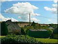
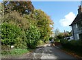
View south-west from the lych gate, Church of St James, Cherhill
Cottages typical of the village are in the foreground with the northern edge of Wiltshire downland visible in the distance.
Image: © Brian Robert Marshall
Taken: 24 Aug 2011
0.08 miles
4
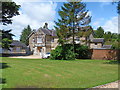
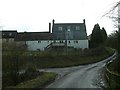
The Old Rectory
The lovely house, built in 1843, is alongside the A4 road. Listed grade II, more details are at: http://www.britishlistedbuildings.co.uk/en-316220-the-old-rectory-cherhill
Image: © Michael Dibb
Taken: 24 Jun 2012
0.08 miles
8
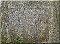
St James, Cherhill: churchyard (c)
Inscription on the grave of Septimus Firman. He was educated at Exeter College Oxford and ordained in 1875. He served his title at Christ Church Battyeford and then a further curacy at St Laurence Kirby Misperton. He was Vicar at St James the Less Liverpool from 1883 to 1906, when he came here. He died in post, Crockford's recording his salary at £311 p/a
Image: © Basher Eyre
Taken: 26 Oct 2022
0.10 miles
9
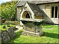
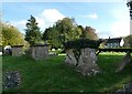
South porch and tomb, Church of St James, Cherhill
This is another view of the south porch which dates to the 15th century. The table tomb in front of it is one of four listed Grade II http://www.imagesofengland.org.uk/details/default.aspx?id=316232 This appears to be the Pottow monument described as follows: 'Pottow monument, later C18 with raised fielded centre plaque each side flanked by fielded strips. Baluster angles, moulded base and cornice with pulvinated frieze. South inscription to H. Pottow, died 1788'
NOTE. This image has a detailed ‘shared description’ which you won’t see by viewing this image on a slideshow. To read it click on the image.
Image: © Brian Robert Marshall
Taken: 24 Aug 2011
0.10 miles
10
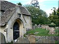
South porch, Church of St James, Cherhill
The origins of the church are 12th or 13th century. The porch is 15th century.
NOTE. This image has a detailed ‘shared description’ which you won’t see by viewing this image on a slideshow. To read it click on the image.
Image: © Brian Robert Marshall
Taken: 24 Aug 2011
0.10 miles