IMAGES TAKEN NEAR TO
Main Road, CALNE, SN11 8UT
Introduction
This page details the photographs taken nearby to Main Road, SN11 8UT by members of the Geograph project.
The Geograph project started in 2005 with the aim of publishing, organising and preserving representative images for every square kilometre of Great Britain, Ireland and the Isle of Man.

There are currently over 7.5m images from over14,400 individuals and you can help contribute to the project by visiting https://www.geograph.org.uk
Image Map
Images are licensed for reuse under creativecommons.org/licenses/by-sa/2.0
Notes
- Clicking on the map will re-center to the selected point.
- The higher the marker number, the further away the image location is from the centre of the postcode.
Image Listing (49 Images Found)
Images are licensed for reuse under creativecommons.org/licenses/by-sa/2.0
Image
Details
Distance
6
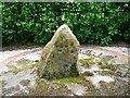
Cherhill bus shelter sundial, Cherhill
The bus shelter is a millennium project. The sundial consists of a vertical sarsen stone inside a 'face' of Roman numerals. The intention is to symbolize the passage of time. The local bus company probably use more modern time-keeping methods.
Image: © Brian Robert Marshall
Taken: 21 May 2008
0.06 miles
7
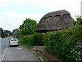
Cherhill bus shelter, Cherhill
The shelter is a millennium project. The timber frame was supplied and erected by a local green oak company and thatched by David Grafton, a local craftsman. Within the shelter is a sundial http://www.geograph.org.uk/photo/811093
Image: © Brian Robert Marshall
Taken: 21 May 2008
0.06 miles
8
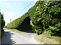
Hedge, The Street
Spectacular hedge, probably leylandii, arched to allow entry to someone's drive.
Image: © Vieve Forward
Taken: 20 May 2018
0.09 miles
9
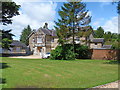
The Old Rectory
The lovely house, built in 1843, is alongside the A4 road. Listed grade II, more details are at: http://www.britishlistedbuildings.co.uk/en-316220-the-old-rectory-cherhill
Image: © Michael Dibb
Taken: 24 Jun 2012
0.14 miles