IMAGES TAKEN NEAR TO
Blackland, CALNE, SN11 8PT
Introduction
This page details the photographs taken nearby to SN11 8PT by members of the Geograph project.
The Geograph project started in 2005 with the aim of publishing, organising and preserving representative images for every square kilometre of Great Britain, Ireland and the Isle of Man.

There are currently over 7.5m images from over14,400 individuals and you can help contribute to the project by visiting https://www.geograph.org.uk
Image Map
Images are licensed for reuse under creativecommons.org/licenses/by-sa/2.0
Notes
- Clicking on the map will re-center to the selected point.
- The higher the marker number, the further away the image location is from the centre of the postcode.
Image Listing (3 Images Found)
Images are licensed for reuse under creativecommons.org/licenses/by-sa/2.0
Image
Details
Distance
1
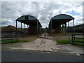
Almost symmetrical
Blackland Farm buildings
Image: © Rob Purvis
Taken: 13 Aug 2017
0.06 miles
2
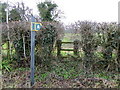
Stile near Blackland
The stile gives walkers access to the footpath that takes them towards Blackland Mill.
Image: © Maigheach-gheal
Taken: 1 Jan 2011
0.15 miles
3
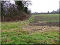
Footpath near Blackland
The map tells us that the footpath should go across the field, unfortunately it is not showing on the ground.
Image: © Maigheach-gheal
Taken: 1 Jan 2011
0.16 miles