IMAGES TAKEN NEAR TO
Britannia Drive, CALNE, SN11 8GH
Introduction
This page details the photographs taken nearby to Britannia Drive, SN11 8GH by members of the Geograph project.
The Geograph project started in 2005 with the aim of publishing, organising and preserving representative images for every square kilometre of Great Britain, Ireland and the Isle of Man.

There are currently over 7.5m images from over14,400 individuals and you can help contribute to the project by visiting https://www.geograph.org.uk
Image Map
Images are licensed for reuse under creativecommons.org/licenses/by-sa/2.0
Notes
- Clicking on the map will re-center to the selected point.
- The higher the marker number, the further away the image location is from the centre of the postcode.
Image Listing (5 Images Found)
Images are licensed for reuse under creativecommons.org/licenses/by-sa/2.0
Image
Details
Distance
1
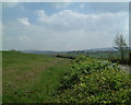
View towards Cherhill Downs
These beautiful green fields are on the outskirts of Calne and will one day be built on. The Cherhill White Horse can be seen to the left of the centre ground.
Image: © Gerry Mooney
Taken: 18 Jan 2000
0.07 miles
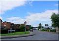
2

Oxford Rd (A3102)
This picture was taken looking North, the entrance to The Bug and Spider can be seen in the centre of the picture.
Image: © Gerry Mooney
Taken: 14 Jan 2000
0.16 miles
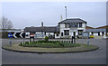
3
Porte Marsh Rd
View west along Porte Marsh Road which runs west from the A3102 Oxford Rd to Stanier Rd in Calne. This is the view from the junction with the Oxford Rd.
Image: © Nigel Mykura
Taken: 15 Jun 2010
0.18 miles
4
The Bug and Spider
Public house on Oxford Road.
Image: © Roger Cornfoot
Taken: 30 Dec 2006
0.22 miles
5
![Newly built [2]](https://s2.geograph.org.uk/geophotos/05/41/85/5418514_c54cd5e8_120x120.jpg)
Newly built [2]
Building and sales offices of the development at Calne Marsh.
Image: © Michael Dibb
Taken: 24 May 2017
0.22 miles