IMAGES TAKEN NEAR TO
Church Street, CALNE, SN11 0HU
Introduction
This page details the photographs taken nearby to Church Street, SN11 0HU by members of the Geograph project.
The Geograph project started in 2005 with the aim of publishing, organising and preserving representative images for every square kilometre of Great Britain, Ireland and the Isle of Man.

There are currently over 7.5m images from over14,400 individuals and you can help contribute to the project by visiting https://www.geograph.org.uk
Image Map
Images are licensed for reuse under creativecommons.org/licenses/by-sa/2.0
Notes
- Clicking on the map will re-center to the selected point.
- The higher the marker number, the further away the image location is from the centre of the postcode.
Image Listing (210 Images Found)
Images are licensed for reuse under creativecommons.org/licenses/by-sa/2.0
Image
Details
Distance
1
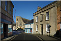
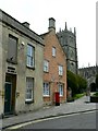
Church Street, Calne
A street in the old town centre. Pictured here is Calne Free Church, the smaller of the two churches in Church Street. The larger St Mary's parish church is behind me.
Image: © Des Blenkinsopp
Taken: 2 Jan 2023
0.00 miles
2
Plaque on the site of the old Harris Factory
For more about Harris see https://historicengland.org.uk/services-skills/education/educational-images/ct-harris-bacon-factory-calne-3308#:~:text=A%20bacon%20factory%20founded%20circa,demolished%20in%20the%20mid%201980s.
Image: © Basher Eyre
Taken: 25 Oct 2022
0.00 miles
3
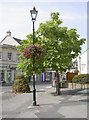
Looking from The Strand towards St Mary's
Image: © Basher Eyre
Taken: 25 Oct 2022
0.01 miles
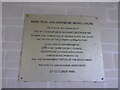
4
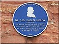
Blue plaque, Church Street, Calne
The plaque commemorates a Dutchman whose connection with the Wiltshire town is that he is buried nearby.
Image: © Brian Robert Marshall
Taken: 21 May 2008
0.01 miles
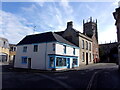
5
Church Street, Calne
In the background is The Parish Church of St Mary the Virgin. The pinkish coloured building shows the blue plaque in this image http://www.geograph.org.uk/photo/810869 Whether the Dutch scientist had any connection with the building isn’t known to me. He is, however, buried in the churchyard.
Image: © Brian Robert Marshall
Taken: 21 May 2008
0.01 miles
7
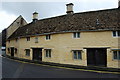
Alms Houses at Calne
Built by John Tomson son of Robert, Bishop of Salisbury c1682, on Kingsbury Street, Calne
Image: © John Sparshatt
Taken: 24 Jun 2005
0.01 miles
9
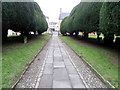
Path, Church of St Mary the Virgin
The path is bordered by yew trees.
The European yew (Taxus boccata) has a reputation for longevity. Whilst there is no direct evidence to support the view that yew trees were association with pagan worship it is not hard to imagine that they were. The yew, a tree symbolising longevity, death and rebirth became woven into folklore and its association with churchyards may simply be that in certain circumstances its foliage and fruit can be poisonous and in medieval England churchyards were one of the few places fenced against stock.
Image: © Maigheach-gheal
Taken: 1 Jan 2011
0.02 miles
10
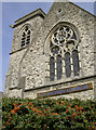
Calne Free Church
This church has been a Free Church since the nineteenth century. As with many such like, the local congregations were unimpressed by some of the high Anglican teachings and broke away to form their own. The foundation stone was laid in 1867 and the church opened on July 28th, 1868, with some 2-300 worshippers attending. The church is Grade II listed.
Image: © Neil Owen
Taken: 22 Sep 2014
0.02 miles