IMAGES TAKEN NEAR TO
Orchard Place, DEVIZES, SN10 4JD
Introduction
This page details the photographs taken nearby to Orchard Place, SN10 4JD by members of the Geograph project.
The Geograph project started in 2005 with the aim of publishing, organising and preserving representative images for every square kilometre of Great Britain, Ireland and the Isle of Man.

There are currently over 7.5m images from over14,400 individuals and you can help contribute to the project by visiting https://www.geograph.org.uk
Image Map (Loading...)


Getting Data...Please wait
Leaflet Map data © OpenStreetMap
Images are licensed for reuse under creativecommons.org/licenses/by-sa/2.0
Notes
- Clicking on the map will re-center to the selected point.
- The higher the marker number, the further away the image location is from the centre of the postcode.
Image Listing (94 Images Found)
Images are licensed for reuse under creativecommons.org/licenses/by-sa/2.0
Image
Details
Distance
1
![Path leaves the road [1]](https://s0.geograph.org.uk/geophotos/06/36/46/6364644_ccb3db85_120x120.jpg)
Path leaves the road [1]
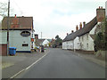
From Orchard Place this footpath runs at the rear of the buildings facing High Street to White Street.
West Lavington, along with Littleton Panell, form a nearly continuous line of ribbon development along the A360 Devizes to Salisbury road on the northern edge of Salisbury Plain. There is evidence of occupation in this area from late Neolithic or early Bronze Age times. The Dauntsey family owned land in the parish from at least 1474 and in 1542 William Dauntsey's bequest founded a school and almshouses.
Image: © Michael Dibb
Taken: 11 Sep 2019
0.02 miles
2
![West Lavington houses [3]](https://s3.geograph.org.uk/geophotos/06/36/20/6362099_b43e7dfa_120x120.jpg)
West Lavington houses [3]
Number 42 High Street is a substantial detached modern house.
West Lavington, along with Littleton Panell, form a nearly continuous line of ribbon development along the A360 Devizes to Salisbury road on the northern edge of Salisbury Plain. There is evidence of occupation in this area from late Neolithic or early Bronze Age times. The Dauntsey family owned land in the parish from at least 1474 and in 1542 William Dauntsey's bequest founded a school and almshouses.
Image: © Michael Dibb
Taken: 11 Sep 2019
0.04 miles
4
![West Lavington houses [2]](https://s2.geograph.org.uk/geophotos/06/36/20/6362098_4bfbf304_120x120.jpg)
West Lavington houses [2]
These thatched houses at numbers 32 and 34 High Street are probably early 18th century and might well have been built as replacements for the houses destroyed in the great fire of 1689.
West Lavington, along with Littleton Panell, form a nearly continuous line of ribbon development along the A360 Devizes to Salisbury road on the northern edge of Salisbury Plain. There is evidence of occupation in this area from late Neolithic or early Bronze Age times. The Dauntsey family owned land in the parish from at least 1474 and in 1542 William Dauntsey's bequest founded a school and almshouses.
Image: © Michael Dibb
Taken: 11 Sep 2019
0.04 miles
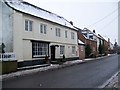
5
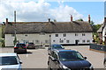
32 & 34 High Street, West Lavington
Thatched houses on the A360, with the car park of the Churchill Arms in the foreground.
Image: © M J Roscoe
Taken: 26 Aug 2020
0.05 miles
6
![West Lavington houses [1]](https://s1.geograph.org.uk/geophotos/06/36/20/6362097_f3448af7_120x120.jpg)
West Lavington houses [1]
Number 30 High Street is late 17th or early 18th century, brick faced and thatched. Originally two bays, extended by one bay on the right in the early 19th century and with a recent weather boarded extension at the rear. Listed, grade II, with details at: https://historicengland.org.uk/listing/the-list/list-entry/1198223
West Lavington, along with Littleton Panell, form a nearly continuous line of ribbon development along the A360 Devizes to Salisbury road on the northern edge of Salisbury Plain. There is evidence of occupation in this area from late Neolithic or early Bronze Age times. The Dauntsey family owned land in the parish from at least 1474 and in 1542 William Dauntsey's bequest founded a school and almshouses.
Image: © Michael Dibb
Taken: 11 Sep 2019
0.05 miles
7
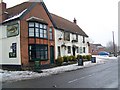
The Churchill Arms, West Lavington
The Churchill is a country pub situated on the High Street.
Image: © Maigheach-gheal
Taken: 14 Jan 2010
0.06 miles
8
![West Lavington buildings [3]](https://s0.geograph.org.uk/geophotos/06/36/20/6362096_0a98af83_120x120.jpg)
West Lavington buildings [3]
The Churchill Arms is named after the Duke of Marlborough who bought the West Lavington estate in 1766.
West Lavington, along with Littleton Panell, form a nearly continuous line of ribbon development along the A360 Devizes to Salisbury road on the northern edge of Salisbury Plain. There is evidence of occupation in this area from late Neolithic or early Bronze Age times. The Dauntsey family owned land in the parish from at least 1474 and in 1542 William Dauntsey's bequest founded a school and almshouses.
Image: © Michael Dibb
Taken: 11 Sep 2019
0.06 miles
9
The Churchill Arms, West Lavington
Served an excellent pint of Wadworth 6X to walkers deviating a short distance from the Wessex Ridgeway path.
Image: © Tim Heaton
Taken: 19 May 2021
0.07 miles
10
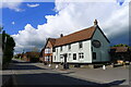
Houses on the High Street, West Lavington
The white house is where the author Nigel Balchin lived and set into its wall is a Victorian postbox. Image, Image
Image: © Maigheach-gheal
Taken: 14 Jan 2010
0.07 miles