IMAGES TAKEN NEAR TO
The Street, DEVIZES, SN10 3NY
Introduction
This page details the photographs taken nearby to The Street, SN10 3NY by members of the Geograph project.
The Geograph project started in 2005 with the aim of publishing, organising and preserving representative images for every square kilometre of Great Britain, Ireland and the Isle of Man.

There are currently over 7.5m images from over14,400 individuals and you can help contribute to the project by visiting https://www.geograph.org.uk
Image Map
Images are licensed for reuse under creativecommons.org/licenses/by-sa/2.0
Notes
- Clicking on the map will re-center to the selected point.
- The higher the marker number, the further away the image location is from the centre of the postcode.
Image Listing (39 Images Found)
Images are licensed for reuse under creativecommons.org/licenses/by-sa/2.0
Image
Details
Distance
1
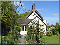
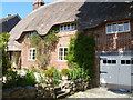
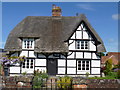
Yew Tree Cottage
The cottage is 17th century, the extension beyond the gable is 20th century. Listed grade II, details are at: http://list.historicengland.org.uk/resultsingle.aspx?uid=1365959 All Cannings has a large number of listed buildings for such a small village.
Image: © Michael Dibb
Taken: 23 May 2015
0.01 miles
2
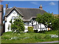
Townend Cottage
This large, thatched, timber framed cottage is from the late 16th or early 17th century. The cottage is listed grade II and details are at: http://list.historicengland.org.uk/resultsingle.aspx?uid=1033784 All Cannings has a large number of listed buildings for such a small village.
Image: © Michael Dibb
Taken: 23 May 2015
0.03 miles
3
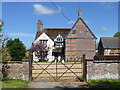
Cliff Farmhouse
This attractive late 16th/early 17th century timber framed farmhouse is listed grade II with details at: http://list.historicengland.org.uk/resultsingle.aspx?uid=1033783 All Cannings has a large number of listed buildings for such a small village.
Image: © Michael Dibb
Taken: 23 May 2015
0.06 miles
4
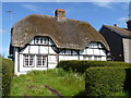
Cottages in The Street
This early 17th century timber framed house is now two cottages. Listed grade II, details are at: http://list.historicengland.org.uk/resultsingle.aspx?uid=1365960 All Cannings has a large number of listed buildings for such a small village.
Image: © Michael Dibb
Taken: 23 May 2015
0.06 miles
5
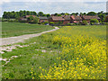
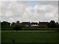
The edge of All Cannings
Modern houses at the northern end of the village. Viewed along the byway from Woodway Bridge on the Kennet and Avon Canal.
Image: © Andrew Smith
Taken: 7 Jun 2008
0.07 miles
6
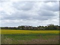
All Cannings
A view from the towpath of the Kennet and Avon Canal across the fields towards All Cannings.
Image: © Michael Dibb
Taken: 23 Apr 2018
0.07 miles
7
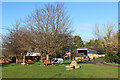
All Cannings
Road junction in All Cannings.
Image: © Wayland Smith
Taken: 24 Dec 2020
0.08 miles
8
Refaced house
This 17th century timber framed house has been refaced in brick. Listed grade II with details at: http://list.historicengland.org.uk/resultsingle.aspx?uid=1286480 All Cannings has a large number of listed buildings for such a small village.
Image: © Michael Dibb
Taken: 23 May 2015
0.08 miles
9
Rustic Farmhouse
This lovely thatched farmhouse is dated to 1593. Listed grade II with details at: http://list.historicengland.org.uk/resultsingle.aspx?uid=1033782 All Cannings has a large number of listed buildings for such a small village.
Image: © Michael Dibb
Taken: 23 May 2015
0.10 miles
10
All Cannings from Kennet and Avon Canal
Image: © Ian Murfitt
Taken: 7 May 2015
0.11 miles