IMAGES TAKEN NEAR TO
The Nursery, DEVIZES, SN10 2AF
Introduction
This page details the photographs taken nearby to The Nursery, SN10 2AF by members of the Geograph project.
The Geograph project started in 2005 with the aim of publishing, organising and preserving representative images for every square kilometre of Great Britain, Ireland and the Isle of Man.

There are currently over 7.5m images from over14,400 individuals and you can help contribute to the project by visiting https://www.geograph.org.uk
Image Map
Images are licensed for reuse under creativecommons.org/licenses/by-sa/2.0
Notes
- Clicking on the map will re-center to the selected point.
- The higher the marker number, the further away the image location is from the centre of the postcode.
Image Listing (217 Images Found)
Images are licensed for reuse under creativecommons.org/licenses/by-sa/2.0
Image
Details
Distance
1
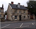
Dolman, Devizes
Building surveyors' office in Sussex House alongside the A361, here named The Nursery.
Image: © Jaggery
Taken: 22 Oct 2014
0.00 miles
2
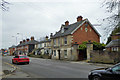
Sussex House, The Nursery, Devizes
A former house, now offices. Probably originally the wharfinger's house for Sussex Wharf, now disused, on the Kennet and Avon Canal which runs behind.
Image: © Robin Webster
Taken: 17 Mar 2018
0.00 miles
3
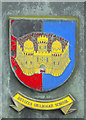
Devizes Grammar School
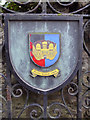
This crest appears on the gates of what is now Braeside Education and Conference Centre, but was for many years part of Devizes Grammar School. In common with many traditional town grammar schools it was effectively closed down in the 1960s. Officially it merged with a local secondary school to become Devizes School in 1969 but the new school no longer used this site. Note that the crest uses the castle as a motif.
Image: © Stephen McKay
Taken: 17 Mar 2018
0.02 miles
4
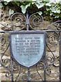
Plaque on gate, Braeside
Now a Wiltshire County Council education and conference centre, Braeside was once part of Devizes Grammar School. On the other gate are its arms - see Image For a glimpse of the building, see Image
Image: © Robin Webster
Taken: 17 Mar 2018
0.02 miles
5
Devizes Grammar School arms
On one of the gates of Braeside, now a Wiltshire County Council education and conference centre. Braeside was once part of Devizes Grammar School. On the other gate is a commemorative plaque - see Image For a glimpse of the building, see Image
Image: © Robin Webster
Taken: 17 Mar 2018
0.02 miles
6
A glimpse of Melbourne House, Devizes
This grade II listed building from about 1840 is set back behind the houses along the street. The listing describes the feature on the roof as a stair light, but it seems more than that.
Image: © Robin Webster
Taken: 17 Mar 2018
0.03 miles
7
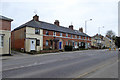
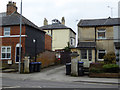
Houses on The Nursery, Devizes
A row called Melbourne Place.
Image: © Robin Webster
Taken: 17 Mar 2018
0.03 miles
8
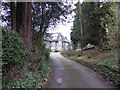
View down the drive of 'Braeside', Devizes
Once Devizes Grammar School and previously a World War I convalescent home or hospital I believe.
Image: © Jeremy Bolwell
Taken: 17 Mar 2018
0.03 miles
9
![Devizes features [10]](https://s2.geograph.org.uk/geophotos/06/08/22/6082250_7b6b46e8_120x120.jpg)
Devizes features [10]
These fine gateposts are at the entrance to The Cedars, a late 18th century, grade II* listed building.
The market town of Devizes developed around its 11th century castle. It gained a charter in 1141 and holds a weekly market in the large and picturesque Market Place. In the 16th century the town became known for its textiles and in the early 18th century held the largest corn market in the West Country. Devizes has about 500 listed buildings - a very large number for a small town.
Image: © Michael Dibb
Taken: 28 Dec 2018
0.03 miles
10
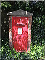
A home of its own
An Edward VII letterbox on the Bath Road stands in its own brick shelter, complete with a fine concrete coping stone. See Image] for a look at its roadside location.
Image: © Neil Owen
Taken: 10 May 2024
0.03 miles