IMAGES TAKEN NEAR TO
Berhills Lane, DEVIZES, SN10 1ST
Introduction
This page details the photographs taken nearby to Berhills Lane, SN10 1ST by members of the Geograph project.
The Geograph project started in 2005 with the aim of publishing, organising and preserving representative images for every square kilometre of Great Britain, Ireland and the Isle of Man.

There are currently over 7.5m images from over14,400 individuals and you can help contribute to the project by visiting https://www.geograph.org.uk
Image Map
Images are licensed for reuse under creativecommons.org/licenses/by-sa/2.0
Notes
- Clicking on the map will re-center to the selected point.
- The higher the marker number, the further away the image location is from the centre of the postcode.
Image Listing (4 Images Found)
Images are licensed for reuse under creativecommons.org/licenses/by-sa/2.0
Image
Details
Distance
1
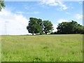
Fields, trees and pylons
As seems to be common in this area, problems are encountered in trying to find anything to photograph other than fields and trees. Well, there is a road with high hedges, but that makes for an even less interesting image. For variety, here we also have an electricity transmission line - actually the same line as that shown in Image
Image: © Doug Lee
Taken: 11 Jun 2006
0.10 miles
4
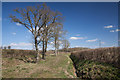
Bridleway in Spring
The hedges have recently been trimmed and the treas have yet to come into leaf. For comparison, Image, shows the same area in summer.
Image: © Doug Lee
Taken: 6 Apr 2013
0.25 miles