1
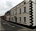
Devizes: Nags Head Court
Looking east along New Park Street, past this building which, I think it's fair to assume, was once a pub called the Nag's Head.
Image: © Chris Downer
Taken: 4 Apr 2009
0.01 miles
2
Town Centre, Devizes
Image: © Maigheach-gheal
Taken: 25 Apr 2007
0.02 miles
3
2009 : A361 New Park Street, Devizes looking east
Heading into Devizes away from the brewery. A search of the www failed to reveal the name of the church.
Image: © Maurice Pullin
Taken: 11 Nov 2009
0.02 miles
4
Rock Community Church, Devizes
A Salem Chapel building dated 1838
Image: © Tim Heaton
Taken: 5 Feb 2018
0.02 miles
5
Fancy Pantz in Devizes
Snuff Street shop selling fancy dress and party accessories.
Image: © Jaggery
Taken: 22 Oct 2014
0.02 miles
6
New Park Street, Devizes
Image: © David Howard
Taken: 21 Aug 2016
0.03 miles
7
Nag's head over the entrance to Nags Head Court, Devizes
On the south side of New Park Street, near the corner of Snuff Street.
Nags Head Court is an apartment building in a converted former pub dating from the 18th century.
Image: © Jaggery
Taken: 22 Oct 2014
0.03 miles
8
Snuff Street, Devizes
Viewed from the corner of New Park Street looking towards The Market Place.
Image: © Jaggery
Taken: 22 Oct 2014
0.03 miles
9
New Park Street, Devizes
Many buildings on this, the A361, are listed. On the left are numbers 32-33, faced in Bath stone https://www.historicengland.org.uk/listing/the-list/list-entry/1250957 , followed by the painted stone of https://www.historicengland.org.uk/listing/the-list/list-entry/1250959 . The red brick house of five bays is described at https://www.historicengland.org.uk/listing/the-list/list-entry/1262698 .
Right of centre is a glimpse of the grade I listed St Mary's Church https://www.historicengland.org.uk/listing/the-list/list-entry/1251640 , shown at http://www.geograph.org.uk/search.php?i=87442355 .
Image: © Derek Harper
Taken: 17 Sep 2018
0.03 miles
10
Northgate Street and Market Place, Devizes, Wiltshire
The Angel Bingo hall is in the Market Place. The first building beyond is also
in the Market Place and those beyond that are in Northgate Street. The bingo
hall was a cinema, built in 1912 and enlarged in the late 1920s. It was
converted to dual use, bingo and cinema, in the 1970s. The façade is Art Deco.
Image: © Brian Robert Marshall
Taken: 4 Sep 2008
0.03 miles


