IMAGES TAKEN NEAR TO
Woodmansterne Lane, BANSTEAD, SM7 3AB
Introduction
This page details the photographs taken nearby to Woodmansterne Lane, SM7 3AB by members of the Geograph project.
The Geograph project started in 2005 with the aim of publishing, organising and preserving representative images for every square kilometre of Great Britain, Ireland and the Isle of Man.

There are currently over 7.5m images from over14,400 individuals and you can help contribute to the project by visiting https://www.geograph.org.uk
Image Map
Images are licensed for reuse under creativecommons.org/licenses/by-sa/2.0
Notes
- Clicking on the map will re-center to the selected point.
- The higher the marker number, the further away the image location is from the centre of the postcode.
Image Listing (50 Images Found)
Images are licensed for reuse under creativecommons.org/licenses/by-sa/2.0
Image
Details
Distance
1
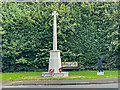
Banstead War Memorial
War memorial unveiled 5 June 1921. Grade II listed - see https://historicengland.org.uk/listing/the-list/list-entry/1458546?section=official-list-entry.
Image: © Ian Capper
Taken: 7 Oct 2022
0.03 miles
2
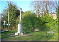
The Banstead War Memorial
110 men's names listed from WW1 & WW2
Image: © The Saunterer
Taken: 19 Feb 2013
0.04 miles
3
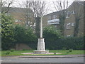
Monument, Banstead
Monument on Road junction, Banstead.
Image: © Henry Spooner
Taken: 22 Apr 2009
0.04 miles
4

Banstead War Memorial
Banstead War Memorial is to be found next to the roundabout at the eastern end of the High Street at the junction with Park Road and Sutton Lane.
Image: © Marathon
Taken: 4 Nov 2013
0.04 miles
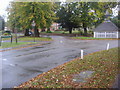
5
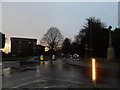
Roundabout at the junction of Park Road and Woodmansterne Lane
The war memorial is on the right
Image: © David Howard
Taken: 14 Jan 2013
0.04 miles
6
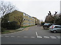
Well House, Banstead
Well House is a complex of privately-owned apartments in Banstead, in north Surrey.
Image: © Malc McDonald
Taken: 11 Jan 2020
0.06 miles
7

Well head
18th Century well head at the junction of Woodmansterne Land and Park Road, still with its winding gear over a 300 foot deep well. Grade II listed - see www.historicengland.org.uk/listing/the-list/list-entry/1178243.
Image: © Ian Capper
Taken: 27 Oct 2018
0.07 miles
8

Well head
18th Century well head at the junction of Woodmansterne Land and Park Road, still with its winding gear over a 300 foot deep well. Grade II listed - see www.historicengland.org.uk/listing/the-list/list-entry/1178243.
Image: © Ian Capper
Taken: 27 Oct 2018
0.07 miles
9
Woodmansterne Lane Banstead
At junction of Park Road
Image: © David Howard
Taken: 11 Oct 2009
0.07 miles
10
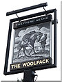
The Woolpack sign
Sign for Image], a Shepherd Neame pub on High Street.
Image: © Oast House Archive
Taken: 20 Aug 2015
0.07 miles