IMAGES TAKEN NEAR TO
Courtlands Crescent, BANSTEAD, SM7 2PL
Introduction
This page details the photographs taken nearby to Courtlands Crescent, SM7 2PL by members of the Geograph project.
The Geograph project started in 2005 with the aim of publishing, organising and preserving representative images for every square kilometre of Great Britain, Ireland and the Isle of Man.

There are currently over 7.5m images from over14,400 individuals and you can help contribute to the project by visiting https://www.geograph.org.uk
Image Map (Loading...)


Getting Data...Please wait
Leaflet Map data © OpenStreetMap
Images are licensed for reuse under creativecommons.org/licenses/by-sa/2.0
Notes
- Clicking on the map will re-center to the selected point.
- The higher the marker number, the further away the image location is from the centre of the postcode.
Image Listing (96 Images Found)
Images are licensed for reuse under creativecommons.org/licenses/by-sa/2.0
Image
Details
Distance
1
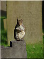
Banstead churchyard
This little varmint was sitting so still that I thought someone had left a plastic squirrel on the grave. I was just composing thoughts on public taste when I realised that it wasn't plastic at all! Ooops!!
Image: © Alan Hunt
Taken: 17 Oct 2010
0.06 miles
2
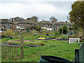
Holly Lane allotments, Banstead
A fenced public footpath cuts diagonally across the rectangular field, dividing it into two triangular parts. This, the north side, is the most popular.
Image: © Robin Webster
Taken: 23 Nov 2010
0.10 miles
3
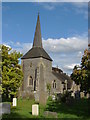
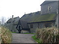
Banstead church
A view of Banstead church from the graveyard.
Image: © Alan Hunt
Taken: 17 Oct 2010
0.12 miles
4
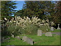
Banstead churchyard
Lush Pampas grass growing in the churchyard.
Image: © Alan Hunt
Taken: 17 Oct 2010
0.12 miles
6
Banstead Church
The porch doorway decorated for a wedding
Image: © Henry Spooner
Taken: 22 Apr 2009
0.13 miles
9
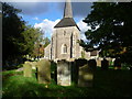
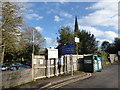
All Saints Church, Banstead
The large churchyard of All Saints, Banstead lies just off the High Street. The tower dates from the late 12th or early 13th centuries but the spire is later.
Image: © Marathon
Taken: 4 Nov 2013
0.13 miles
10

Banstead Church
A perfect late summer's afternoon.
Image: © Peter Trimming
Taken: 11 Sep 2007
0.13 miles