IMAGES TAKEN NEAR TO
Holly Lane West, BANSTEAD, SM7 2BB
Introduction
This page details the photographs taken nearby to Holly Lane West, SM7 2BB by members of the Geograph project.
The Geograph project started in 2005 with the aim of publishing, organising and preserving representative images for every square kilometre of Great Britain, Ireland and the Isle of Man.

There are currently over 7.5m images from over14,400 individuals and you can help contribute to the project by visiting https://www.geograph.org.uk
Image Map (Loading...)


Getting Data...Please wait
Leaflet Map data © OpenStreetMap
Images are licensed for reuse under creativecommons.org/licenses/by-sa/2.0
Notes
- Clicking on the map will re-center to the selected point.
- The higher the marker number, the further away the image location is from the centre of the postcode.
Image Listing (14 Images Found)
Images are licensed for reuse under creativecommons.org/licenses/by-sa/2.0
Image
Details
Distance
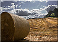
1
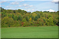
Early autumn tints
Autumn colours are starting to appear on the trees bordering Chipstead Road, at this point now only a footpath.
Image: © Robin Webster
Taken: 6 Oct 2010
0.12 miles
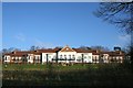
2
Chatsworth Park
Chatsworth Park is a rather exclusive development of flats on the edge of Banstead. This is the view from the entrance gate in Holly Lane.
Image: © Marathon
Taken: 16 Apr 2014
0.12 miles
3
Chatsworth Park, Banstead
A residential development above Holly Lane in Banstead.
Image: © Hugh Craddock
Taken: 28 Dec 2008
0.12 miles
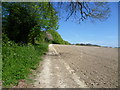
4
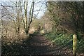
Chipstead Road
This green lane, now a public footpath (Banstead 622), is marked on the map as Chipstead Road, connecting the Brighton Road (A217) with Holly Lane. However, the footpath behind the photographer soon veers off to the north-east, and the last 150 metres to Holly Lane is either overgrown or has been cultivated. Taken from the junction with footpaths 43 and 44.
Image: © Hugh Craddock
Taken: 28 Dec 2008
0.13 miles
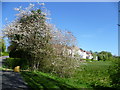
5
Footpath to Park Road
This footpath leads from Holly Lane, just before the first houses are reached from the east, to eventually reach Park Road. Considering we had just come out of the wettest winter on record, the ground was already very dry by April.
Image: © Marathon
Taken: 16 Apr 2014
0.15 miles
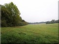
6
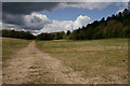
Banstead
Farmland to the south of the village.
Image: © Peter Trimming
Taken: 5 May 2021
0.16 miles
7
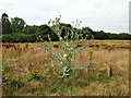
Monster thistle
An example of a Cotton Thistle, Onopordum acanthium. Not the tallest thistle I've seen, Marsh Thistles can sometimes grow higher than this, but still impressive.
Image: © Robin Webster
Taken: 4 Aug 2019
0.17 miles
8
Banstead
Looking along the line of the footpath, towards Ruffett Wood.
Image: © Peter Trimming
Taken: 5 May 2021
0.17 miles
9
Holly Lane
Farmland adjoining Holly Lane
Image: © Kurseong Carl
Taken: 12 Sep 2009
0.19 miles
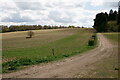
10
Valley by Ruffett Wood
One arm of the valley which runs down to Chipstead and is shown there in Image Image is on the right; to the left, Chipstead Road has become a mere track along the edge of woodland on the south edge of Banstead.
Image: © Derek Harper
Taken: 12 Oct 2007
0.19 miles