IMAGES TAKEN NEAR TO
Beacon Close, BANSTEAD, SM7 1EL
Introduction
This page details the photographs taken nearby to Beacon Close, SM7 1EL by members of the Geograph project.
The Geograph project started in 2005 with the aim of publishing, organising and preserving representative images for every square kilometre of Great Britain, Ireland and the Isle of Man.

There are currently over 7.5m images from over14,400 individuals and you can help contribute to the project by visiting https://www.geograph.org.uk
Image Map
Images are licensed for reuse under creativecommons.org/licenses/by-sa/2.0
Notes
- Clicking on the map will re-center to the selected point.
- The higher the marker number, the further away the image location is from the centre of the postcode.
Image Listing (14 Images Found)
Images are licensed for reuse under creativecommons.org/licenses/by-sa/2.0
Image
Details
Distance
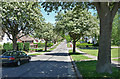
4
Nork: Nork Rise
Off the north side of Nork Way
Image: © Dr Neil Clifton
Taken: 25 Sep 2014
0.15 miles
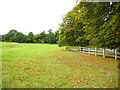
6
Nork Park
Nork did not exist until the 18th or 19th century when it was an agricultural hamlet of Banstead village. It was named after its house built during the reign of Charles II. Nork Park is part of the old estate of Nork House, which was bought by the former Banstead Council in 1947. The park includes the site of Nork House which was demolished around 1930. There are extensive views from the park across West London to Wembley Stadium and beyond.
Image: © Marathon
Taken: 4 Nov 2013
0.16 miles
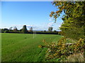
7
Nork Park
Nork did not exist until the 18th or 19th century when it was an agricultural hamlet of Banstead village. It was named after its house built during the reign of Charles II. Nork Park is part of the old estate of Nork House, which was bought by the former Banstead Council in 1947. The park includes the site of Nork House which was demolished around 1930. There are extensive views from the park across West London to Wembley Stadium and beyond.
Image: © Marathon
Taken: 4 Nov 2013
0.16 miles
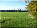
8
View from Nork Park
Nork did not exist until the 18th or 19th century when it was an agricultural hamlet of Banstead village. It was named after its house built during the reign of Charles II. Nork Park is part of the old estate of Nork House, which was bought by the former Banstead Council in 1947. The park includes the site of Nork House which was demolished around 1930. There are extensive views from the park across West London to Wembley Stadium and beyond.
Image: © Marathon
Taken: 4 Nov 2013
0.18 miles
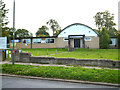
9
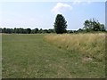
Nork Park
Nork Park public open space. As well as playing fields, the park also has a section where the grassland is allowed to grow naturally and also a children's play area.
Image: © Hywel Williams
Taken: 14 Jul 2005
0.19 miles
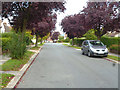
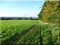
10
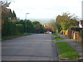
View from Tumblewood Road
There are superb views down Tumblewood Road, right across West London. It is difficult to appreciate how high Banstead is until you see a view like this.
Image: © Marathon
Taken: 4 Nov 2013
0.20 miles