IMAGES TAKEN NEAR TO
Sandy Lane South, WALLINGTON, SM6 9NW
Introduction
This page details the photographs taken nearby to Sandy Lane South, SM6 9NW by members of the Geograph project.
The Geograph project started in 2005 with the aim of publishing, organising and preserving representative images for every square kilometre of Great Britain, Ireland and the Isle of Man.

There are currently over 7.5m images from over14,400 individuals and you can help contribute to the project by visiting https://www.geograph.org.uk
Image Map (Loading...)


Getting Data...Please wait
Leaflet Map data © OpenStreetMap
Images are licensed for reuse under creativecommons.org/licenses/by-sa/2.0
Notes
- Clicking on the map will re-center to the selected point.
- The higher the marker number, the further away the image location is from the centre of the postcode.
Image Listing (31 Images Found)
Images are licensed for reuse under creativecommons.org/licenses/by-sa/2.0
Image
Details
Distance
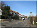
1
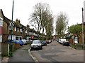
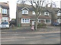
Edwardian housing
Typical street in this area. Wallington grew rapidly after the railway came, with this entire block being built up in the early years of the 20th century. Note that the houses are all similar but not identical - this was part of the original design, although further modifications have clearly been made by homeowners in the intervening period.
Image: © Colin Bell
Taken: 22 Mar 2008
0.06 miles
2
45 & 47, Marchmont Road
It appears that the house names of Image were replaced by numbers, perhaps after more houses had been built in the surrounding locality.
Image: © John Baker
Taken: 18 Nov 2014
0.06 miles
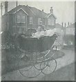
3
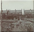
Bramshot, Marchmont Road, Wallington in 1911
View taken by my paternal grandfather George W Baker looking towards the back of the house from the garden
Image: © George W Baker
Taken: Unknown
0.07 miles
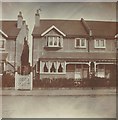
5
41 & 43, Marchmont Road
Part of number 43 can be seen in Image, to the left of this house.
Image: © John Baker
Taken: 18 Nov 2014
0.07 miles
6
Bramshot & Cwmnant, Marchmont Road, Wallington in 1908
View taken by my paternal grandfather George W Baker of the first house (Bramshot) he owned after he had got married.
Image: © George W Baker
Taken: Unknown
0.07 miles
7
Marchmont Road, Wallington in 1909
View taken by my paternal grandfather George W Baker (not only of his eldest son (Alwyne George Russell born in 1908) but also) of the house opposite his http://www.geograph.org.uk/photo/2187283 and two of the houses in Avenue Road.
Image: © George W Baker
Taken: Unknown
0.07 miles
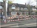
8
Shirley Road at the junction of Sandy Hill Road
Image: © David Howard
Taken: 15 Jun 2014
0.08 miles
9
Houses in Avenue Road
Compared with Image, it appears that the houses seen in Avenue Road have been replaced with more modern versions.
Image: © John Baker
Taken: 18 Nov 2014
0.09 miles
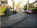
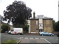
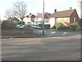
10
Sandy Lane South, near Wallington
Sandy Lane South is a residential road in the outer suburbs of south London.
Image: © Malc McDonald
Taken: 19 Feb 2023
0.10 miles