IMAGES TAKEN NEAR TO
New Barn Close, WALLINGTON, SM6 9GB
Introduction
This page details the photographs taken nearby to New Barn Close, SM6 9GB by members of the Geograph project.
The Geograph project started in 2005 with the aim of publishing, organising and preserving representative images for every square kilometre of Great Britain, Ireland and the Isle of Man.

There are currently over 7.5m images from over14,400 individuals and you can help contribute to the project by visiting https://www.geograph.org.uk
Image Map (Loading...)


Getting Data...Please wait
Leaflet Map data © OpenStreetMap
Images are licensed for reuse under creativecommons.org/licenses/by-sa/2.0
Notes
- Clicking on the map will re-center to the selected point.
- The higher the marker number, the further away the image location is from the centre of the postcode.
Image Listing (22 Images Found)
Images are licensed for reuse under creativecommons.org/licenses/by-sa/2.0
Image
Details
Distance
1
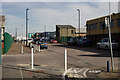
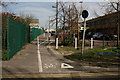
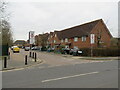
Imperial Way
One of the industrial estates close to Purley Way, Croydon.
Image: © Peter Trimming
Taken: 10 Mar 2015
0.08 miles
2
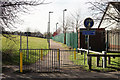
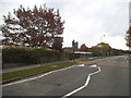
Footpath Across Roundshaw Park
Located on the northern edge of the park.
Image: © Peter Trimming
Taken: 10 Mar 2015
0.11 miles
4
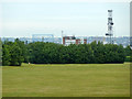
Croydon Airport Industrial Estate
Seen from the edge of Roundshaw Park.
Image: © Peter Trimming
Taken: 10 Mar 2015
0.12 miles
5
Imperial Way
One of the industrial estates close to Purley Way, Croydon.
Image: © Peter Trimming
Taken: 10 Mar 2015
0.12 miles
7
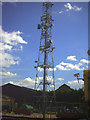
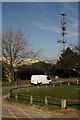
Mast, Imperial Way, South Croydon.
In the grounds of an anonymous factory.
Image: © Noel Foster
Taken: 4 Aug 2005
0.13 miles
8
View north from Roundshaw Downs
Looking towards Waddon House on Stafford Road.
Image: © Robin Webster
Taken: 6 Jun 2011
0.13 miles
9
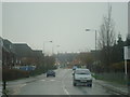
Roe Way, near Wallington
Roe Way is a residential cul-de-sac near Wallington, in the outer suburbs of south London.
Traffic signs indicate that motor vehicles are prohibited from using this road at school starting and finishing times. This is to prevent the road being used by parents dropping off or picking up children from a neighbouring school, making the road safer for children walking or cycling to and from school. The restriction does not apply to local residents with a permit.
Image: © Malc McDonald
Taken: 4 Mar 2023
0.13 miles
10
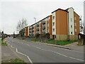
Mollison Drive, near Wallington
Mollison Drive is a residential road near Wallington, in the outer suburbs of south London. A modern apartment block stands on the opposite side of the road.
Image: © Malc McDonald
Taken: 4 Mar 2023
0.13 miles