IMAGES TAKEN NEAR TO
Barlow Close, WALLINGTON, SM6 9DR
Introduction
This page details the photographs taken nearby to Barlow Close, SM6 9DR by members of the Geograph project.
The Geograph project started in 2005 with the aim of publishing, organising and preserving representative images for every square kilometre of Great Britain, Ireland and the Isle of Man.

There are currently over 7.5m images from over14,400 individuals and you can help contribute to the project by visiting https://www.geograph.org.uk
Image Map (46 Images)


Getting Data...Please wait
Leaflet Map data © OpenStreetMap
Images are licensed for reuse under creativecommons.org/licenses/by-sa/2.0
Notes
- Clicking on the map will re-center to the selected point.
- The higher the marker number, the further away the image location is from the centre of the postcode.
Image Listing (46 Images Found)
Images are licensed for reuse under creativecommons.org/licenses/by-sa/2.0
Image
Details
Distance
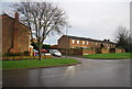
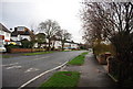
5
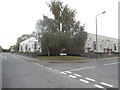
Redford Avenue at the junction of Defiant Way
Image: © David Howard
Taken: 18 Oct 2015
0.08 miles
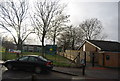
6
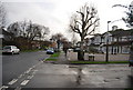
Redford Avenue at its junction with Waterers Rise
Image: © N Chadwick
Taken: 27 Feb 2011
0.09 miles
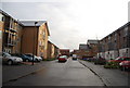
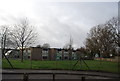
10
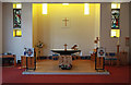
St Paul, Mollison Drive, Roundshaw Estate - Chancel
Image: © John Salmon
Taken: 23 May 2011
0.14 miles