IMAGES TAKEN NEAR TO
Upper Road, WALLINGTON, SM6 8JY
Introduction
This page details the photographs taken nearby to Upper Road, SM6 8JY by members of the Geograph project.
The Geograph project started in 2005 with the aim of publishing, organising and preserving representative images for every square kilometre of Great Britain, Ireland and the Isle of Man.

There are currently over 7.5m images from over14,400 individuals and you can help contribute to the project by visiting https://www.geograph.org.uk
Image Map (51 Images)


Getting Data...Please wait
Leaflet Map data © OpenStreetMap
Images are licensed for reuse under creativecommons.org/licenses/by-sa/2.0
Notes
- Clicking on the map will re-center to the selected point.
- The higher the marker number, the further away the image location is from the centre of the postcode.
Image Listing (51 Images Found)
Images are licensed for reuse under creativecommons.org/licenses/by-sa/2.0
Image
Details
Distance
1
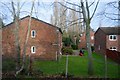
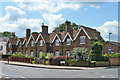
Row of cottages, Plough Lane, Beddington.
Built in 1859, they're on the corner of Plough Lane (B272) and Sandy Lane North.
Image: © Noel Foster
Taken: 3 Sep 2005
0.05 miles
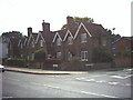
4
Cottages on Plough Lane, Beddington
Built in the mid 19th century for workers on the Carew Estate. Grade II listed.
Image: © Robin Webster
Taken: 29 Jun 2011
0.08 miles
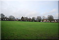
8
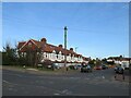
The Chase, near Wallington
The Chase is a residential road near Wallington, in the suburbs of south London.
Image: © Malc McDonald
Taken: 19 Feb 2023
0.10 miles
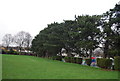
9
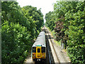
The 11:53 from Victoria between Waddon and Wallington
Unit 455 835 has just passed under bridge NFE 262, Plough Lane.
Image: © Robin Webster
Taken: 29 Jun 2011
0.11 miles