IMAGES TAKEN NEAR TO
Rookwood Avenue, WALLINGTON, SM6 8HQ
Introduction
This page details the photographs taken nearby to Rookwood Avenue, SM6 8HQ by members of the Geograph project.
The Geograph project started in 2005 with the aim of publishing, organising and preserving representative images for every square kilometre of Great Britain, Ireland and the Isle of Man.

There are currently over 7.5m images from over14,400 individuals and you can help contribute to the project by visiting https://www.geograph.org.uk
Image Map (Loading...)


Getting Data...Please wait
Leaflet Map data © OpenStreetMap
Images are licensed for reuse under creativecommons.org/licenses/by-sa/2.0
Notes
- Clicking on the map will re-center to the selected point.
- The higher the marker number, the further away the image location is from the centre of the postcode.
Image Listing (34 Images Found)
Images are licensed for reuse under creativecommons.org/licenses/by-sa/2.0
Image
Details
Distance
1
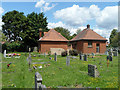
Buildings in Bandon Hill cemetery
Mapped as the mortuary.
Image: © Robin Webster
Taken: 29 Jun 2011
0.05 miles
3
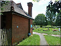
Pedestrian path into Bandon Hill cemetery
A rather hidden away entrance from the end of Rookwood Avenue. The sign says it is open 8:30 to 4:30 or sunset Monday to Friday, which looks a bit like school times. Two other signs say no dogs.
Image: © Robin Webster
Taken: 29 Jun 2011
0.07 miles
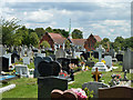
5
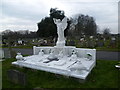
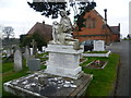
Lincoln monument in Bandon Hill Cemetery
Bandon Hill Cemetery was opened in 1900 by the Croydon Rural District Council and, due to boundary changes, later became a joint burial authority for the Corporation of Beddington and Wallington and the Coulsdon and Purley Urban District Council. The first interment in Bandon Hill Cemetery took place on March 7th 1900.
With the formation of the London Boroughs in 1965, the Cemetery became jointly run by the London Boroughs of Croydon and Sutton.
The Lincoln monument is the largest in the Cemetery.
Image: © Marathon
Taken: 6 Mar 2013
0.08 miles
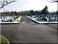
7
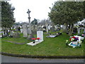
Bandon Hill Cemetery
Bandon Hill Cemetery was opened in 1900 by the Croydon Rural District Council and, due to boundary changes, later became a joint burial authority for the Corporation of Beddington and Wallington and the Coulsdon and Purley Urban District Council. The first interment in Bandon Hill Cemetery took place on March 7th 1900.
With the formation of the London Boroughs in 1965, the Cemetery became jointly run by the London Boroughs of Croydon and Sutton.
Image: © Marathon
Taken: 6 Mar 2013
0.10 miles
9
Bandon Hill Cemetery
Bandon Hill Cemetery was opened in 1900 by the Croydon Rural District Council and, due to boundary changes, later became a joint burial authority for the Corporation of Beddington and Wallington and the Coulsdon and Purley Urban District Council. The first interment in Bandon Hill Cemetery took place on March 7th 1900.
With the formation of the London Boroughs in 1965, the Cemetery became jointly run by the London Boroughs of Croydon and Sutton. In this view the chapel complex can be seen ahead.
Image: © Marathon
Taken: 6 Mar 2013
0.11 miles
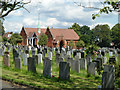
10
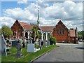
Chapel buildings, Bandon Hill cemetery
There appear to be two chapels here, with a cloistered link.
Image: © Robin Webster
Taken: 29 Jun 2011
0.12 miles