IMAGES TAKEN NEAR TO
Boundary Road, WALLINGTON, SM6 0TE
Introduction
This page details the photographs taken nearby to Boundary Road, SM6 0TE by members of the Geograph project.
The Geograph project started in 2005 with the aim of publishing, organising and preserving representative images for every square kilometre of Great Britain, Ireland and the Isle of Man.

There are currently over 7.5m images from over14,400 individuals and you can help contribute to the project by visiting https://www.geograph.org.uk
Image Map (Loading...)


Getting Data...Please wait
Leaflet Map data © OpenStreetMap
Images are licensed for reuse under creativecommons.org/licenses/by-sa/2.0
Notes
- Clicking on the map will re-center to the selected point.
- The higher the marker number, the further away the image location is from the centre of the postcode.
Image Listing (21 Images Found)
Images are licensed for reuse under creativecommons.org/licenses/by-sa/2.0
Image
Details
Distance
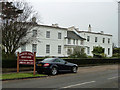
1
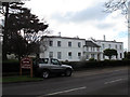
Woodcote Hall, Wallington
The building pre-dates the suburban development around it, with a history dating back to the sixteenth century, although the present building only incorporates small parts of the original building. Most of the land around it was sold for housing development in the early 20th century, and in the 1980s the hall itself was converted to a smaller number of residential units. It is now grade 2 listed (list entry 1184092). See also Image
Image: © Stephen Craven
Taken: 6 Feb 2015
0.17 miles
2
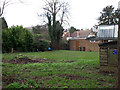
Land behind St Patrick's church, Wallington
For the church itself, see Image
Image: © Stephen Craven
Taken: 6 Feb 2015
0.17 miles
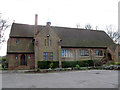
3
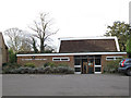
St Patrick's church hall, Wallington
The hall was built in 1965 to replace an earlier structure that had burnt down. For the adjacent church, see Image
Image: © Stephen Craven
Taken: 6 Feb 2015
0.17 miles
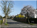
4
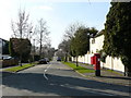
Street Scene, Briar Lane, Carshalton
View to the west, where Telegraph Track joins the road.
Image: © Peter Trimming
Taken: 17 Mar 2009
0.17 miles
5
Woodcote Hall
An older building in this area, it is now converted into flats.
Image: © Robin Webster
Taken: 27 Nov 2010
0.17 miles
6
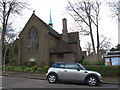
St Patrick's church, Wallington: north side
The church on Park Hill Road was built 1932-35 to the designs of Greenaway and Newberry, as a daughter church of Holy Trinity at the other end of town Image, to serve the rapidly growing suburb around it. It is still a lively Anglican congregation in the evangelical tradition. See also Image
Image: © Stephen Craven
Taken: 6 Feb 2015
0.18 miles
7
Street Scene, Heathdene Road, Carshalton
Cherry blossom on the tree shows that Spring is almost here.
Image: © Peter Trimming
Taken: 17 Mar 2009
0.18 miles
8
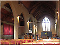
St Patrick's church, Wallington: nave
For the outside of the church, see Image The interior is distinctive for its pale lime brick columns, reminiscent of Newberry's other church in the area, St John's Selsdon Image The original pews have been replaced with contemporary chairs.
Image: © Stephen Craven
Taken: 6 Feb 2015
0.18 miles
9
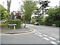
Woodcote Avenue at the junction of Park Hill Road
Image: © David Howard
Taken: 15 Jun 2014
0.19 miles
10
St Patrick's church, Wallington: east end
The church on Park Hill Road was built 1932-35 to the designs of Greenaway and Newberry, as a daughter church of Holy Trinity at the other end of town Image, to serve the rapidly growing suburb around it. It is still a lively Anglican congregation in the evangelical tradition. See also Image
Image: © Stephen Craven
Taken: 6 Feb 2015
0.19 miles