IMAGES TAKEN NEAR TO
Hawthorn Road, WALLINGTON, SM6 0SX
Introduction
This page details the photographs taken nearby to Hawthorn Road, SM6 0SX by members of the Geograph project.
The Geograph project started in 2005 with the aim of publishing, organising and preserving representative images for every square kilometre of Great Britain, Ireland and the Isle of Man.

There are currently over 7.5m images from over14,400 individuals and you can help contribute to the project by visiting https://www.geograph.org.uk
Image Map (Loading...)


Getting Data...Please wait
Leaflet Map data © OpenStreetMap
Images are licensed for reuse under creativecommons.org/licenses/by-sa/2.0
Notes
- Clicking on the map will re-center to the selected point.
- The higher the marker number, the further away the image location is from the centre of the postcode.
Image Listing (70 Images Found)
Images are licensed for reuse under creativecommons.org/licenses/by-sa/2.0
Image
Details
Distance
1
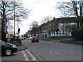
Stanley Park Road, Wallington
The road forms part of the B271 from Carshalton to Croydon.
Image: © Stephen Craven
Taken: 6 Feb 2015
0.07 miles
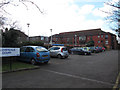
2
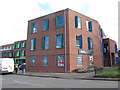
Jubilee Health Centre, Wallington
The centre opened in 2012 and is at the corner of Shotfields and Stanley Park Road. The white van was delivering supplies to the pharmacy.
Image: © Stephen Craven
Taken: 6 Feb 2015
0.09 miles
3
Flats on Stanley Park Road, Wallington
The Jubilee Health Centre is on the left
Image: © David Howard
Taken: 20 Sep 2015
0.09 miles
4
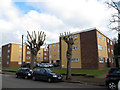
Burns Court, Park Hill Road, Wallington
The development consists of three blocks of flats.
Image: © Stephen Craven
Taken: 6 Feb 2015
0.09 miles
5
Cloverdale Court, Wallington
Sheltered housing and day care centre.
Image: © Stephen Craven
Taken: 6 Feb 2015
0.11 miles
6
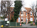
Gaytime Nursery, Stanley Park Road, Wallington
A large suburban house now in use as a children's nursery.
Image: © Stephen Craven
Taken: 6 Feb 2015
0.11 miles
7
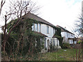
Abandoned house, Stanley Park Road, Wallington
Boarded up and overgrown with creepers, this house looks to have been uninhabited for a long time.
Image: © Stephen Craven
Taken: 6 Feb 2015
0.12 miles
8
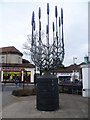
Sculpture to the lavender industry, Wallington
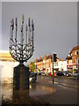
Lavender and herb growing were very prominent in the area in Victorian times and much earlier, and extensive fields of lavender were to be seen in the Carshalton, Beddington and Wallington areas. Lavender growing was a very prosperous part of the local agriculture hereabouts in the 19th and early 20th centuries. In Wallington the area to the north of the station was chiefly used. The scale of the operation can be understood from the fact that the Daily News in 1914 was able to state that at Carshalton Beeches “In every direction the low hill sides of the farm beyond Beeches Halt are swept with the bloomy pastel tint of the lavender flowers”. This sculpture at the junction of Woodcote Road and Stafford Road commemorates the local lavender industry.
Image: © Marathon
Taken: 6 Mar 2013
0.12 miles
9
Lavender sculpture, Wallington crossroads
The slopes of the North Downs in what is now the London Borough of Sutton have been a centre for lavender cultivation for centuries. This sculpture is one of the ways the area marks this heritage; among others, local Scouts use lavender as the logo for the Sutton area on their shoulder badges.
Image: © Christopher Hilton
Taken: 20 Apr 2012
0.12 miles
10
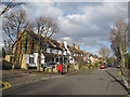
Park Hill Road, Wallington
Looking downhill from the junction with Heathdene Road, with a postbox on the corner.
Image: © Stephen Craven
Taken: 6 Feb 2015
0.12 miles