IMAGES TAKEN NEAR TO
Stanley Park Road, WALLINGTON, SM6 0EX
Introduction
This page details the photographs taken nearby to Stanley Park Road, SM6 0EX by members of the Geograph project.
The Geograph project started in 2005 with the aim of publishing, organising and preserving representative images for every square kilometre of Great Britain, Ireland and the Isle of Man.

There are currently over 7.5m images from over14,400 individuals and you can help contribute to the project by visiting https://www.geograph.org.uk
Image Map
Images are licensed for reuse under creativecommons.org/licenses/by-sa/2.0
Notes
- Clicking on the map will re-center to the selected point.
- The higher the marker number, the further away the image location is from the centre of the postcode.
Image Listing (107 Images Found)
Images are licensed for reuse under creativecommons.org/licenses/by-sa/2.0
Image
Details
Distance
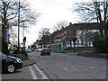
1
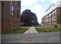
Flats on Stanley Park Road, Wallington
The Jubilee Health Centre is on the left
Image: © David Howard
Taken: 20 Sep 2015
0.02 miles
2
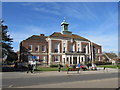
Wallington Town Hall
Robert Atkinson who had lived locally from 1908 until 1925, was the architect who worked in the traditional classical style. The foundation stone was laid at the north-east corner in May 1934, and it was built by Messrs. Perry (Ealing) Ltd., being formally opened by the local Member of Parliament, Sir Richard Meller, on 21st September the following year.
Image: © Richard Rogerson
Taken: 5 Mar 2014
0.03 miles
3
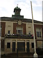
Wallington Town Hall
Still in use, but since 1965 simply a local centre within the larger London Borough of Sutton.
Image: © Christopher Hilton
Taken: 20 Apr 2012
0.03 miles
4

Memorial Plaque by fountain. Wallington Library
Remembering Julia Thurston B.E.M. 1938 - 1994
For her voluntary and civic contributions
Service beyond self
By Image]
Image: © Rich Tea
Taken: 17 Jun 2008
0.03 miles

6
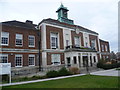
Former town hall, Wallington
After the First World War, the population of Wallington increased rapidly and the local Urban District Council outgrew its various offices and so, in 1929, purchased an old house, Sunny Bank, in Woodcote Road and decided to commission a new Town Hall, to be built on Sunny Banks site. The Council became a Borough in 1937, and the Town Hall was the hub of community life up until the incorporation of Beddington and Wallington into the London Borough of Sutton in 1964, and even then, the Council Chamber was used for the new Council's meetings until 1977. Parts of the building continued to be used by other organisations such as the WRVS, the Registrar of Births, Marriages and Deaths, and as a Driving Test Centre. In 1980 it was taken over and converted into a Crown Court. The building ceased to be a Court in April 1999, and has now been converted for educational use.
Image: © Marathon
Taken: 6 Mar 2013
0.04 miles
7
Stanley Park Road, Wallington
The road forms part of the B271 from Carshalton to Croydon.
Image: © Stephen Craven
Taken: 6 Feb 2015
0.04 miles
8

Orchard Hill College, Wallington
Previously Wallington Town Hall
Image: © Rich Tea
Taken: 17 Jun 2008
0.04 miles
9
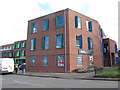
Jubilee Health Centre, Wallington
The centre opened in 2012 and is at the corner of Shotfields and Stanley Park Road. The white van was delivering supplies to the pharmacy.
Image: © Stephen Craven
Taken: 6 Feb 2015
0.04 miles
10
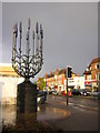
Lavender sculpture, Wallington crossroads
The slopes of the North Downs in what is now the London Borough of Sutton have been a centre for lavender cultivation for centuries. This sculpture is one of the ways the area marks this heritage; among others, local Scouts use lavender as the logo for the Sutton area on their shoulder badges.
Image: © Christopher Hilton
Taken: 20 Apr 2012
0.04 miles