IMAGES TAKEN NEAR TO
Grosvenor Road, WALLINGTON, SM6 0EF
Introduction
This page details the photographs taken nearby to Grosvenor Road, SM6 0EF by members of the Geograph project.
The Geograph project started in 2005 with the aim of publishing, organising and preserving representative images for every square kilometre of Great Britain, Ireland and the Isle of Man.

There are currently over 7.5m images from over14,400 individuals and you can help contribute to the project by visiting https://www.geograph.org.uk
Image Map
Images are licensed for reuse under creativecommons.org/licenses/by-sa/2.0
Notes
- Clicking on the map will re-center to the selected point.
- The higher the marker number, the further away the image location is from the centre of the postcode.
Image Listing (90 Images Found)
Images are licensed for reuse under creativecommons.org/licenses/by-sa/2.0
Image
Details
Distance
1
Dark skies over Wallington Station Car park
Image: © N Chadwick
Taken: 4 Feb 2018
0.07 miles
2
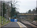
Wallington station
Wallington station opened on 10th May 1847 by the London, Brighton & South Coast Railway on the new Croydon to Epsom railway. Wallington at that time was just a small hamlet around Wallington Green. What is now central Wallington was just fields. The new station, which stood some distance from the hamlet, was called Carshalton as that was the largest nearby place it was built to serve. The population expanded around the new station and when in 1868 Carshalton was finally given its own station on the newly-opened Sutton to Mitcham Junction line, the old Carshalton station became Wallington station.
The bridge immediately ahead carries a footbridge and the one beyond is for Park Lane.
Image: © Marathon
Taken: 6 Mar 2013
0.09 miles
3
Wallington station
Wallington station opened on 10th May 1847 by the London, Brighton & South Coast Railway on the new Croydon to Epsom railway. Wallington at that time was just a small hamlet around Wallington Green. What is now central Wallington was just fields. The new station, which stood some distance from the hamlet, was called Carshalton as that was the largest nearby place it was built to serve. The population expanded around the new station and when in 1868 Carshalton was finally given its own station on the newly-opened Sutton to Mitcham Junction line, the old Carshalton station became Wallington station.
Image: © Marathon
Taken: 6 Mar 2013
0.09 miles
5
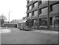
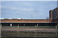
New bus station at Wallington
The surroundings of Wallington station had just been remodelled, allowing for the construction of a small station on the south side, when this photograph was taken. It shows a Leyland National on Route 127, from Purley to Tooting Broadway, which had just been introduced, but which has survived until the present (2007) albeit double-deckers are now used.
See the bus station in 2008 Image]
Image: © Dr Neil Clifton
Taken: 28 Jan 1984
0.10 miles
9
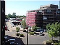
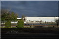
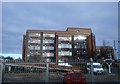
Wallington Station forecourt
From the 3rd floor of Carew House. The building covered in scaffolding is Beddington House. It was formerly offices of Homebase, and is now being refurbished.
Image: © Rich Tea
Taken: 8 May 2008
0.11 miles
10
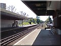
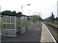
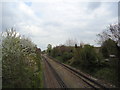
Wallington Station, platform 1 looking west
Towards Sutton
Image: © Rich Tea
Taken: 8 May 2008
0.11 miles