IMAGES TAKEN NEAR TO
Briar Banks, CARSHALTON, SM5 4QB
Introduction
This page details the photographs taken nearby to Briar Banks, SM5 4QB by members of the Geograph project.
The Geograph project started in 2005 with the aim of publishing, organising and preserving representative images for every square kilometre of Great Britain, Ireland and the Isle of Man.

There are currently over 7.5m images from over14,400 individuals and you can help contribute to the project by visiting https://www.geograph.org.uk
Image Map
Images are licensed for reuse under creativecommons.org/licenses/by-sa/2.0
Notes
- Clicking on the map will re-center to the selected point.
- The higher the marker number, the further away the image location is from the centre of the postcode.
Image Listing (12 Images Found)
Images are licensed for reuse under creativecommons.org/licenses/by-sa/2.0
Image
Details
Distance
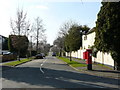
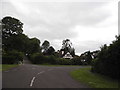
1
View From Telegraph Track
In this landscape view, you would not know that housing is so close.
Image: © Peter Trimming
Taken: 17 Mar 2009
0.08 miles
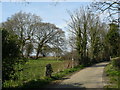
2
Telegraph Track reaches Carshalton Beeches
Surrey County Council first bought land at Woodcote in 1912, but after the First World War they made substantial purchases in the Little Woodcote area, on either side of Woodmansterne Lane. The main purpose was to provide smallholdings so that ex-servicemen who wanted to farm on a small scale had the chance to do so as tenants of the County Council. They built the semi-detached farm houses with uniform black weatherboarding and white window frames seen all about in the area. Over the years many of the smallholdings have been given up but a number still remain and some of the plots still grow vegetables. Much of the land purchased by Surrey in this area became the backbone of the Green Belt hereabouts after the Second World War.
In keeping with the set up of the times, the roads do not seem to have normal names. This photograph is of Telegraph Track just as it is leaving the Little Woodcote Estate and enters Boundary Road in Carshalton on the Hill. Telegraph Track connects Carshalton on the Hill with Little Woodcote and crosses Oak Track at right angles.
Image: © Marathon
Taken: 30 Apr 2014
0.10 miles
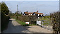
3
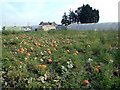
Pumpkin patch by Oaks Track SM6
There are a number of market gardens in this area.
Image: © Philip Talmage
Taken: 4 Sep 2005
0.10 miles
4
Melbourne Nursery, Woodmansterne Lane SM6
Image: © Philip Talmage
Taken: 4 Sep 2005
0.10 miles
5
Sandown Drive, Carshalton, Surrey
Apartment block known as Sandown Drive - April 1981
Image: © Bob Scarlett
Taken: 1 Apr 1981
0.10 miles
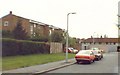
6
Street Scene, Briar Lane, Carshalton
View to the west, where Telegraph Track joins the road.
Image: © Peter Trimming
Taken: 17 Mar 2009
0.11 miles
7
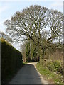
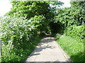
View Along Telegraph Track, Woodcote
The view along this quiet Bridleway, which is a concreted track.
Image: © Peter Trimming
Taken: 17 Mar 2009
0.11 miles
8
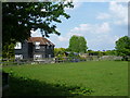
House on the Little Woodcote Estate
Surrey County Council first bought land at Woodcote in 1912, but after the First World War they made substantial purchases in the Little Woodcote area, on either side of Woodmansterne Lane. The main purpose was to provide smallholdings so that ex-servicemen who wanted to farm on a small scale had the chance to do so as tenants of the County Council. They built the semi-detached farm houses with uniform black weatherboarding and white window frames. Over the years many of the smallholdings have been given up but a number still remain and some of the plots still grow vegetables. This one is seen here from Telegraph Track. Much of the land purchased by Surrey in this area became the backbone of the Green Belt hereabouts after the Second World War.
In keeping with the set up of the times, the roads do not seem to have normal names. This photograph is taken from Telegraph Track which connects Carshalton on the Hill with Little Woodcote and crosses Oak Track at right angles.
Image: © Marathon
Taken: 30 Apr 2014
0.20 miles
9
Woodcote Avenue, Wallington
Part of the private Woodcote Green estate, so one view you won't be able to find on Streetview.
Image: © David Howard
Taken: 15 Jun 2014
0.22 miles
10
View From Telegraph Track
View along Telegraph Track to the north. The house to the right of the track is one of several timber-faced houses in the locality.
Image: © Peter Trimming
Taken: 17 Mar 2009
0.22 miles