IMAGES TAKEN NEAR TO
Southdown Road, CARSHALTON, SM5 4LT
Introduction
This page details the photographs taken nearby to Southdown Road, SM5 4LT by members of the Geograph project.
The Geograph project started in 2005 with the aim of publishing, organising and preserving representative images for every square kilometre of Great Britain, Ireland and the Isle of Man.

There are currently over 7.5m images from over14,400 individuals and you can help contribute to the project by visiting https://www.geograph.org.uk
Image Map
Images are licensed for reuse under creativecommons.org/licenses/by-sa/2.0
Notes
- Clicking on the map will re-center to the selected point.
- The higher the marker number, the further away the image location is from the centre of the postcode.
Image Listing (7 Images Found)
Images are licensed for reuse under creativecommons.org/licenses/by-sa/2.0
Image
Details
Distance
2

Sandown Drive, Carshalton
The block of flats known as Sandown Drive. The block is located at the South end of Stanley Road and was built in 1977. This image was taken in 1979.
Image: © Bob Scarlett
Taken: 1 Sep 1979
0.12 miles
3
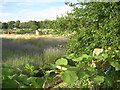
Lavender meadow and allotments, behind the houses on Stanley Square
Lavender has long been grown in this area of the North Downs: Christmas decorations in the London Borough of Sutton take the form of illuminated lavender, local scout troupes wear it as their distinguishing shoulder patch, and so forth. The crop is still grown commercially at a few locations in the area.
Image: © Christopher Hilton
Taken: 4 Jul 2014
0.18 miles
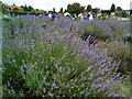
5
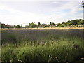
Lavender meadow and allotments, behind the houses on Stanley Square
Lavender has long been grown in this area of the North Downs: Christmas decorations in the London Borough of Sutton take the form of illuminated lavender, local scout troupes wear it as their distinguishing shoulder patch, and so forth. The crop is still grown commercially at a few locations in the area.
Image: © Christopher Hilton
Taken: 4 Jul 2014
0.20 miles
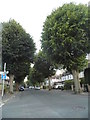
6
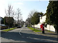
Street Scene, Briar Lane, Carshalton
View to the west, where Telegraph Track joins the road.
Image: © Peter Trimming
Taken: 17 Mar 2009
0.21 miles
7
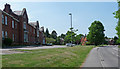
Former Queen Mary's Hospital, Carshalton Beeches
A former NHS site much of which now seems to be a modern housing estate (behind and to the left of photographer). Signs indicate that a number of clinics still operate here, including perhaps the main building on the left, while the three other buildings visible are disused and boarded-up. See here for a fuller history: Image]
Image: © Stephen Richards
Taken: Unknown
0.25 miles