IMAGES TAKEN NEAR TO
Wellfield Gardens, CARSHALTON, SM5 4EA
Introduction
This page details the photographs taken nearby to Wellfield Gardens, SM5 4EA by members of the Geograph project.
The Geograph project started in 2005 with the aim of publishing, organising and preserving representative images for every square kilometre of Great Britain, Ireland and the Isle of Man.

There are currently over 7.5m images from over14,400 individuals and you can help contribute to the project by visiting https://www.geograph.org.uk
Image Map
Images are licensed for reuse under creativecommons.org/licenses/by-sa/2.0
Notes
- Clicking on the map will re-center to the selected point.
- The higher the marker number, the further away the image location is from the centre of the postcode.
Image Listing (28 Images Found)
Images are licensed for reuse under creativecommons.org/licenses/by-sa/2.0
Image
Details
Distance
1
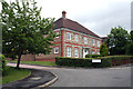
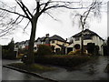
Carshalton Beeches: Wellfield Gardens
High-end housing has been built on land formerly occupied by a medical research centre.
Image: © Dr Neil Clifton
Taken: 22 Jun 2012
0.02 miles
2
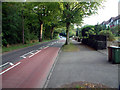
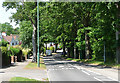
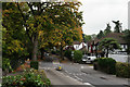
B278 Woodmansterne Road
Looking south, from the end of The Warren.
Image: © Philip Talmage
Taken: 4 Sep 2005
0.02 miles
3
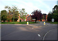
Orchard Hill (formerly Queen Mary's Hospital) Carshalton, Surrey SM5
Orchard Hill, run by Sutton and Merton Primary Care Trust, is an old long-stay hospital that provides a home to over 100 adults with learning and physical disabilities. In 1896, the Metropolitan Asylums Board acquired a 136-acre site at Carshalton on which they intended to construct a 800-bed convalescent hospital, to be known as the Southern Hospital. Buildings for this purpose were erected on the site in 1907-8. However, on 1st September 1908, the MAB was given the additional responsibility of dealing with "sick or convalescent or debilitated children". It was therefore decided to adapt Carshalton as a general hospital for one thousand children under the name of the Children's Hospital. The former Gore Farm Hospital at Darenth, previously mainly used by convalescing smallpox patients, took on a more general convalescent role and also inherited the name of the Southern Hospital. In 1914, following the accession of King George the Fifth and Queen Mary to the throne, the Children's Hospital was renamed Queen Mary's Hospital for Children.
Image: © Philip Talmage
Taken: 4 Sep 2005
0.02 miles
4
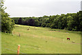
Carshalton Beeches: Fields with horses
Image: © Dr Neil Clifton
Taken: 22 Jun 2012
0.08 miles
5
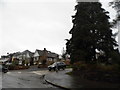
Woodmansterne Road, Carshalton Beeches
The B278, looking north towards Carshalton.
Image: © Stephen Richards
Taken: Unknown
0.09 miles
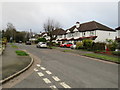
6
Houses on Woodmansterne Road, Carshalton Beeches
Image: © David Howard
Taken: 14 Jan 2013
0.12 miles
7
Woodmansterne Road at the junction of The Warren
Image: © David Howard
Taken: 14 Jan 2013
0.16 miles
8
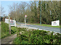
30 limit for Carshalton Beeches
A public bridleway leaves the road here, and a permissive one follows the road through trees along its west side behind the camera.
Image: © Robin Webster
Taken: 30 Mar 2012
0.16 miles
9
Carshalton Beeches
Woodmansterne Road.
Image: © Peter Trimming
Taken: 18 Oct 2015
0.17 miles
10
South Rise, Carshalton Beeches
South Rise is a residential road in Carshalton Beeches, in the outer suburbs of south London.
Image: © Malc McDonald
Taken: 11 Jan 2020
0.19 miles