
IMAGES TAKEN NEAR TO
Festival Walk, CARSHALTON, SM5 3NY
Introduction
This page details the photographs taken nearby to Festival Walk, SM5 3NY by members of the Geograph project.
The Geograph project started in 2005 with the aim of publishing, organising and preserving representative images for every square kilometre of Great Britain, Ireland and the Isle of Man.

There are currently over 7.5m images from over14,400 individuals and you can help contribute to the project by visiting https://www.geograph.org.uk
Image Map
Images are licensed for reuse under creativecommons.org/licenses/by-sa/2.0
Notes
- Clicking on the map will re-center to the selected point.
- The higher the marker number, the further away the image location is from the centre of the postcode.
Image Listing (388 Images Found)
Images are licensed for reuse under creativecommons.org/licenses/by-sa/2.0
Image
Details
Distance
1
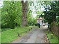
Base of the tallest London plane in Britain, Festival Walk, Carshalton
Ahead is the base of one of the Great Trees of London. This is the tallest London plane in Britain. In 1964 it was 164 feet tall and had a girth of over 20 feet five feet above the ground. The plaque on the ground just to the right of the tree describes this - for a close up of the plaque see http://www.geograph.org.uk/photo/2993649 To the right is The Old Rectory, now part of the Sutton Ecology Centre and to the left is one of the dried up tributaries of the River Wandle. This flowed from St Philomena's Lake past Margaret's Well and into the western of the two Carshalton Ponds. It has been known to be full of water on occasions but is more often dry as it was here, even in the middle of the wettest June on record.
Image: © Marathon
Taken: 13 Jun 2012
0.02 miles
3
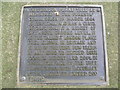
Plaque next to the tallest London plane in Britain, Festival Walk, Carshalton
This plaque is next to the base of one of the Great Trees of London. This is the tallest London plane in Britain - see http://www.geograph.org.uk/photo/2993640
Image: © Marathon
Taken: 13 Jun 2012
0.02 miles
5
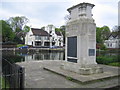
Carshalton: War Memorial
Carshalton's War Memorial is on the north side of the western of Carshalton's ponds, and on the south side of Honeywood Walk. The Greyhound Hotel is visible across the pond to the left of the Memorial and Honeywood House is visible to the right.
Image: © Nigel Cox
Taken: 25 Apr 2007
0.02 miles
6
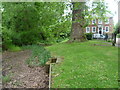
The tallest London plane in Britain, Festival Walk, Carshalton
Ahead is the base of one of the Great Trees of London. This is the tallest London plane in Britain. In 1964 it was 164 feet tall and had a girth of over 20 feet five feet above the ground. The plaque on the ground just to the right of the tree describes this - for a close up of the plaque see http://www.geograph.org.uk/photo/2993649 To the right is The Old Rectory, now part of the Sutton Ecology Centre and to the left is one of the dried up tributaries of the River Wandle. This flowed from St Philomena's Lake past Margaret's Well and into the western of the two Carshalton Ponds. It has been known to be full of water on occasions but is more often dry as here, even in the middle of the wettest June on record.
Image: © Marathon
Taken: 13 Jun 2012
0.02 miles
7
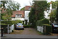
8, West St
Grade II listed. https://www.britishlistedbuildings.co.uk/101065636-6-and-8-west-street-carshalton-central-ward
Image: © N Chadwick
Taken: 23 Aug 2017
0.02 miles
8
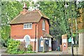
The Gate House
Grade II listed. https://www.britishlistedbuildings.co.uk/101357617-the-gate-house-carshalton-central-ward
Image: © N Chadwick
Taken: 23 Aug 2017
0.03 miles
9

2 and 4 West Street
A pair of 19th Century buildings in West Street, both grade II listed - for no 4, on the left, see https://historicengland.org.uk/listing/the-list/list-entry/1357614?section=official-list-entry and for no 2, on the right, see https://historicengland.org.uk/listing/the-list/list-entry/1183963?section=official-list-entry.
Image: © Ian Capper
Taken: 25 Apr 2023
0.03 miles
10
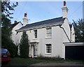
Georgian house in West Street
One of a number of handsome Georgian houses along the east side of the street. This one is at the southern end of the street, not far from the Water Tower. Its neighbour to the left is one of a number of weather-boarded houses in West Street.
For the listing text, see: http://www.britishlistedbuildings.co.uk/en-206812-4-west-street-greater-london-authority
Image: © Stefan Czapski
Taken: 3 Nov 2013
0.03 miles