IMAGES TAKEN NEAR TO
Staplehurst Road, CARSHALTON, SM5 3JX
Introduction
This page details the photographs taken nearby to Staplehurst Road, SM5 3JX by members of the Geograph project.
The Geograph project started in 2005 with the aim of publishing, organising and preserving representative images for every square kilometre of Great Britain, Ireland and the Isle of Man.

There are currently over 7.5m images from over14,400 individuals and you can help contribute to the project by visiting https://www.geograph.org.uk
Image Map
Images are licensed for reuse under creativecommons.org/licenses/by-sa/2.0
Notes
- Clicking on the map will re-center to the selected point.
- The higher the marker number, the further away the image location is from the centre of the postcode.
Image Listing (20 Images Found)
Images are licensed for reuse under creativecommons.org/licenses/by-sa/2.0
Image
Details
Distance
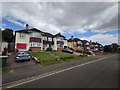
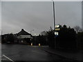
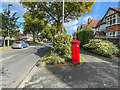
2
Carshalton Beeches
Staplehurst Road.
Image: © Peter Trimming
Taken: 18 Oct 2015
0.13 miles
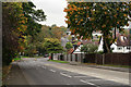
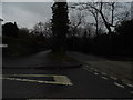
3
Staplehurst Road dropping westwards into the valley
The B278 (Beeches Avenue / Woodmansterne Road) follows a valley southwards out of Carshalton: Staplehurst Road here forms part of an east-west route that dips into that valley and up out on the other side.
Image: © Christopher Hilton
Taken: 4 Jul 2014
0.14 miles
4
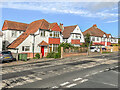
Woodmansterne Road
c.1920/30s houses in Woodmansterne Road.
Image: © Ian Capper
Taken: 7 Oct 2022
0.16 miles
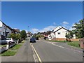
5
Beeches Avenue at the junction of Staplehurst Road
Image: © David Howard
Taken: 14 Jan 2013
0.17 miles
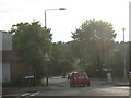
6
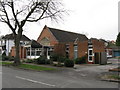
Beeches Baptist church, Carshalton Beeches, Surrey
Image: © Dr Neil Clifton
Taken: 15 Feb 2008
0.20 miles
7
Fullerton Road - Carshalton Beeches
Steep road going up - close to the edge of the suburbs.
Image: © James Emmans
Taken: 11 May 2020
0.20 miles
8
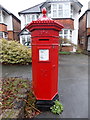
Carshalton: postbox № SM5 49, Beeches Avenue
A rather fine example of the Victorian 'Penfold' design, essentially the predecessor to the cylindrical form which has been the norm since the 1870s.
The box is one of many across the country which, during the last quarter of 2014, have had alterations made to the collection times as part of the Royal Mail's "Collection on Delivery" scheme. The box is now emptied during the postman's delivery round, hence the (not earlier than) 9am stated on the box for weekdays. Below that, it explains that the nearby box at Queen Mary's Avenue, has a 4pm or later collection; and that the Croydon Mail Centre box has the area's latest weekday time, 7:30pm.
The scheme, which is being rolled out nationwide in late 2014/early 2015, affects mainly suburban postboxes which average fewer than 50 items posted per day. The information plates of affected boxes will gradually be updated, as this one already has, giving details of the nearest box with an afternoon weekday collection. The scheme aims to maintain all postboxes in the current network, safeguarding their existence while not being a costly exercise to go round in the evenings collecting from boxes which have very little in them.
Image: © Chris Downer
Taken: 31 Jan 2015
0.21 miles
9
Beeches Avenue
Looking north along Beeches Avenue. The road has seen various names over time: Beechnut Tree Road on the 1895 25 inch map, The Beeches on the 1915 map (when this section was first developed), The Beeches Avenue on the 1935 map and finally its current name, Beeches Avenue (without a "The") on current maps. On the right is the Penfold postbox in Image
Image: © Ian Capper
Taken: 7 Oct 2022
0.21 miles
10
South Rise at the junction of Woodmansterne Road
Image: © David Howard
Taken: 14 Jan 2013
0.21 miles