IMAGES TAKEN NEAR TO
Nutfield Close, CARSHALTON, SM5 2RQ
Introduction
This page details the photographs taken nearby to Nutfield Close, SM5 2RQ by members of the Geograph project.
The Geograph project started in 2005 with the aim of publishing, organising and preserving representative images for every square kilometre of Great Britain, Ireland and the Isle of Man.

There are currently over 7.5m images from over14,400 individuals and you can help contribute to the project by visiting https://www.geograph.org.uk
Image Map
Images are licensed for reuse under creativecommons.org/licenses/by-sa/2.0
Notes
- Clicking on the map will re-center to the selected point.
- The higher the marker number, the further away the image location is from the centre of the postcode.
Image Listing (54 Images Found)
Images are licensed for reuse under creativecommons.org/licenses/by-sa/2.0
Image
Details
Distance
1
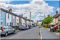
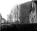
St James Road
Road of mainly 19th Century terraced housing first marked on the 1896 25 inch map. In the background, in front of a self storage warehouse, is the sewer vent column in Image
Image: © Ian Capper
Taken: 25 Apr 2023
0.03 miles
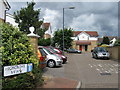
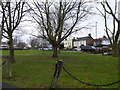
3
William Street
Road marked on the 1871 6 inch map as "Private Street" with the current name shown on the 1896 25 inch map. These maps show the housing as long terraces, since redeveloped.
Image: © Ian Capper
Taken: 25 Apr 2023
0.05 miles
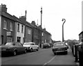
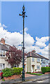
4

Sewer vent column, St James Road
Sewer vent column in St James Road, one of at least 31 such columns in the old Carshalton UDC area (see description below - this is no 22 on the map). This example has the arrow below the globe at the top of the column. Grade II listed - see https://historicengland.org.uk/listing/the-list/list-entry/1469870?section=official-list-entry. For another photo of the same column see Image and for wider views see Image, Image and Image The self storage warehouse in the background was built on the site of the former gas storage tank, demolished in c.2018. See Image for a photo from 1983 of the same column with the gas storage tank in situ.
Image: © Ian Capper
Taken: 25 Apr 2023
0.05 miles
5
Sewer vent column, St James Road
Sewer vent column in St James Road, one of at least 31 such columns in the old Carshalton UDC area (see description below - this is no 22 on the map). This example has the arrow below the globe at the top of the column. Grade II listed - see https://historicengland.org.uk/listing/the-list/list-entry/1469870?section=official-list-entry. For a wider view see Image
Image: © Ian Capper
Taken: 25 Apr 2023
0.05 miles
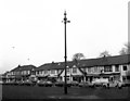
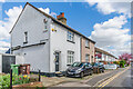
6
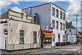
King's Parade
Row of buildings on Wrythe Lane, with nos 4 - 5, the taller block towards the right of the photo, named Cumberland Court. The ornate section behind the current façade on the left of the photo is marked on the 1871 6 inch map and was a pub, the Rose Inn, which closed in 1912 when its licence wasn't renewed.
Image: © Ian Capper
Taken: 25 Apr 2023
0.06 miles