IMAGES TAKEN NEAR TO
Gurney Road, CARSHALTON, SM5 2JX
Introduction
This page details the photographs taken nearby to Gurney Road, SM5 2JX by members of the Geograph project.
The Geograph project started in 2005 with the aim of publishing, organising and preserving representative images for every square kilometre of Great Britain, Ireland and the Isle of Man.

There are currently over 7.5m images from over14,400 individuals and you can help contribute to the project by visiting https://www.geograph.org.uk
Image Map
Images are licensed for reuse under creativecommons.org/licenses/by-sa/2.0
Notes
- Clicking on the map will re-center to the selected point.
- The higher the marker number, the further away the image location is from the centre of the postcode.
Image Listing (214 Images Found)
Images are licensed for reuse under creativecommons.org/licenses/by-sa/2.0
Image
Details
Distance
1
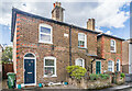
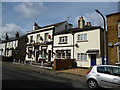
7 - 11 Palmerston Road
Cottages in Palmerston Road, a 19th Century cul-de-sac off Mill Street. The plaque on the near pair of cottages reads "St Anns Cottages 1868". Compare Image which shows a pair of cottages on the opposite side of the road, with a plaque "St Annes Cottages 1868".
Image: © Ian Capper
Taken: 25 Apr 2023
0.03 miles
2
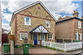
5 & 5a Palmerston Road
A pair of cottages in Palmerston Road, a 19th Century cul-de-sac off Mill Street. It was originally a single house, shown as such on the 1956 1:1250 map, for example.
Image: © Ian Capper
Taken: 25 Apr 2023
0.03 miles
3
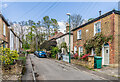
Palmerston Road
19th Century cul-de-sac off Mill Street. At the end of the road, below the embankment carrying the Mitcham Junction to Sutton railway, is the sewer vent column in Image
The plaque on the pair of cottages on the right reads "St. Annes Cottages 1868" - compare Image which shows a pair of cottages on the opposite side of the road, with a plaque "St Anns Cottages 1868".
Image: © Ian Capper
Taken: 25 Apr 2023
0.03 miles
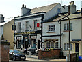
6
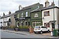
The Palmerston
Pub in Mill Street, dating from 1868 and historically the Lord Palmerston but with the name shortened in 2016.
Image: © Ian Capper
Taken: 25 Apr 2023
0.03 miles
7
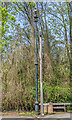
Sewer vent column, Palmerston Road
Sewer vent column at the end of Palmerston Road, one of at least 31 such columns in the old Carshalton UDC area (see description below - this is no 18 on the map). This example has the arrow below the globe at the top of the column. Grade II listed - see https://historicengland.org.uk/listing/the-list/list-entry/1469015?section=official-list-entry. For a wider view see Image A similar column used to stand at the end of Station Road, the adjacent cul-de-sac to the south, but is no longer there - see Image for a photo in 1983.
Image: © Ian Capper
Taken: 25 Apr 2023
0.04 miles
8
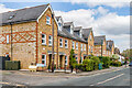
Carshalton: The 'Lord Palmerston', Mill Lane
Image: © Dr Neil Clifton
Taken: 14 Apr 2012
0.04 miles
9
Three street name plates
Three different styles of street name plates at the start of Palmerston Road off Mill Lane.
Image: © Ian Capper
Taken: 25 Apr 2023
0.04 miles
10
40 - 48 Mill Lane
Two terraces built c.2000 as part of the Grove Mill Place redevelopment behind the road.
Image: © Ian Capper
Taken: 25 Apr 2023
0.04 miles