IMAGES TAKEN NEAR TO
Sweetbriar Avenue, CARSHALTON, SM5 2FW
Introduction
This page details the photographs taken nearby to Sweetbriar Avenue, SM5 2FW by members of the Geograph project.
The Geograph project started in 2005 with the aim of publishing, organising and preserving representative images for every square kilometre of Great Britain, Ireland and the Isle of Man.

There are currently over 7.5m images from over14,400 individuals and you can help contribute to the project by visiting https://www.geograph.org.uk
Image Map
Images are licensed for reuse under creativecommons.org/licenses/by-sa/2.0
Notes
- Clicking on the map will re-center to the selected point.
- The higher the marker number, the further away the image location is from the centre of the postcode.
Image Listing (43 Images Found)
Images are licensed for reuse under creativecommons.org/licenses/by-sa/2.0
Image
Details
Distance
1
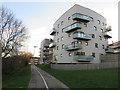
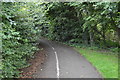
Shared path and new apartments, Hackbridge
A shared path for pedestrians and cyclists, passing a new housing development in Hackbridge, in the outer suburbs of south London.
Image: © Malc McDonald
Taken: 4 Jan 2020
0.07 miles
2
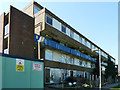
Flats slated for demolition
One of several similar blocks on the estate, all now demolished.
Image: © Robin Webster
Taken: 28 Mar 2012
0.07 miles
3
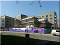
The Lavender being built
It now seems to be known as Lavender Point.
Image: © Robin Webster
Taken: 28 Mar 2012
0.09 miles
4
Millside, Hackbridge
Millside is a short residential cul-de-sac in Hackbridge, in the outer suburbs of south London.
Image: © Malc McDonald
Taken: 4 Jan 2020
0.10 miles
5
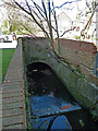
River Wandle backwater
Entering a culvert under Culvers Avenue.
Image: © Robin Webster
Taken: 28 Mar 2012
0.11 miles
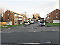
6
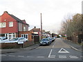
Kingswood Drive, Hackbridge
Kingswood Drive is a residential road in Hackbridge, in the outer suburbs of south London.
Image: © Malc McDonald
Taken: 4 Jan 2020
0.12 miles
7
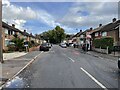
Culvers Avenue, Hackbridge
At the end of the road, under the trees, flows the river Wandle.
Image: © Nigel Thompson
Taken: 22 Oct 2022
0.14 miles
8
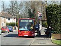
The route to prison
A bus marks time at the Reynolds Close terminus of route 80, whilst intending passengers wait for the driver to open the door for business.
Image: © Robin Webster
Taken: 28 Mar 2012
0.15 miles
10
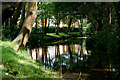
River Wandle at Hackbridge
Looking up river, in the direction of Beddington and Croydon. A quiet river location, in a residential area.
Image: © Peter Trimming
Taken: 5 Aug 2011
0.15 miles