IMAGES TAKEN NEAR TO
Tewkesbury Road, CARSHALTON, SM5 1QH
Introduction
This page details the photographs taken nearby to Tewkesbury Road, SM5 1QH by members of the Geograph project.
The Geograph project started in 2005 with the aim of publishing, organising and preserving representative images for every square kilometre of Great Britain, Ireland and the Isle of Man.

There are currently over 7.5m images from over14,400 individuals and you can help contribute to the project by visiting https://www.geograph.org.uk
Image Map (Loading...)


Getting Data...Please wait
Leaflet Map data © OpenStreetMap
Images are licensed for reuse under creativecommons.org/licenses/by-sa/2.0
Notes
- Clicking on the map will re-center to the selected point.
- The higher the marker number, the further away the image location is from the centre of the postcode.
Image Listing (12 Images Found)
Images are licensed for reuse under creativecommons.org/licenses/by-sa/2.0
Image
Details
Distance
1
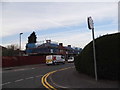
Welbeck Road at the corner of Thornton Road
Image: © David Howard
Taken: 24 Mar 2014
0.11 miles
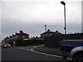
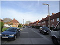
3
Wigmore Road
Kerb parking to help the flow of traffic.
Image: © James Emmans
Taken: 2 Sep 2016
0.12 miles
4
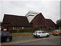
Bishop Andrewes' Church of England - Built 1932
Website : http://www.parishofsthelier.co.uk/about-us/bishop-andrewes
Image: © James Emmans
Taken: 2 Sep 2016
0.13 miles

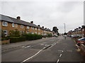
8
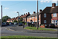
Winchcombe Road, St Helier
At the junction with Waltham Road. Part of the St Helier Estate which was built as an 'overspill' estate by the former London County Council in 1928-36 under their architect, G. Topham Forrest. Influenced by the 'garden city' movement which, as it suggests, involved extensive use of green space and trees, and drawing on traditions of vernacular building.
Since 'right to buy', it is of course now a mixture of public and private.
Image: © Stephen Richards
Taken: Unknown
0.22 miles
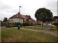
10
Winchcombe Road
Junction with Welhouse Road.
Image: © James Emmans
Taken: 2 Sep 2016
0.24 miles